

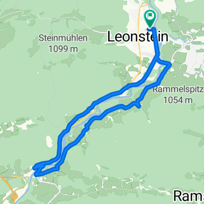
Inzersdorf im Kremstal - Steinbach am Ziehberg (Ortszentren, Umgehung von Hauptverkehrsstraßen)
A cycling route starting in Micheldorf in Oberösterreich, Upper Austria, Austria.
Overview
About this route
From the center, you briefly cross the main street and then follow Sportplatzstraße for about a kilometer, then you turn right before Pyhrnpass street and follow the Kremstalradweg for about 2 km until it turns left towards the highway and valley. Instead, you should continue straight towards Lauterbach. In that place, the path roughly follows the main street, then continues for about 2 km on Ottsdorfer Straße. In the village of the same name, you turn right onto Ziehberg Landstraße L553, after which a very challenging ascent of about 220 meters in elevation begins. After about 3 km, this is over, followed by a very pleasant descent of 3.5 km that ends in the center of the village of Steinbach, where the municipal office, a church, and a supermarket are located.
Duration: 45-60 minutes
- -:--
- Duration
- 12.9 km
- Distance
- 268 m
- Ascent
- 154 m
- Descent
- ---
- Avg. speed
- ---
- Max. altitude
Route quality
Waytypes & surfaces along the route
Waytypes
Quiet road
5.7 km
(44 %)
Access road
0.1 km
(1 %)
Undefined
7.1 km
(55 %)
Surfaces
Paved
11.9 km
(92 %)
Asphalt
11.9 km
(92 %)
Undefined
1 km
(8 %)
Continue with Bikemap
Use, edit, or download this cycling route
You would like to ride Inzersdorf im Kremstal - Steinbach am Ziehberg (Ortszentren, Umgehung von Hauptverkehrsstraßen) or customize it for your own trip? Here is what you can do with this Bikemap route:
Free features
- Save this route as favorite or in collections
- Copy & plan your own version of this route
- Sync your route with Garmin or Wahoo
Premium features
Free trial for 3 days, or one-time payment. More about Bikemap Premium.
- Navigate this route on iOS & Android
- Export a GPX / KML file of this route
- Create your custom printout (try it for free)
- Download this route for offline navigation
Discover more Premium features.
Get Bikemap PremiumFrom our community
Other popular routes starting in Micheldorf in Oberösterreich
 zum See über Klaus am Radweg
- Distance
- 19.2 km
- Ascent
- 185 m
- Descent
- 177 m
- Location
- Micheldorf in Oberösterreich, Upper Austria, Austria
 OBK Jagahäusl
- Distance
- 45.5 km
- Ascent
- 716 m
- Descent
- 734 m
- Location
- Micheldorf in Oberösterreich, Upper Austria, Austria
 2025_08_18_Micheldorf-Weyregg
- Distance
- 66.8 km
- Ascent
- 1,770 m
- Descent
- 1,754 m
- Location
- Micheldorf in Oberösterreich, Upper Austria, Austria
 Von Klaus an der Pyhrnbahn bis Rosenau am Hengstpaß
- Distance
- 33.1 km
- Ascent
- 1,053 m
- Descent
- 756 m
- Location
- Micheldorf in Oberösterreich, Upper Austria, Austria
 2025_04_29_Micheldorf- Hochberghaus-Micheldorf
- Distance
- 75.1 km
- Ascent
- 1,885 m
- Descent
- 1,886 m
- Location
- Micheldorf in Oberösterreich, Upper Austria, Austria
 RK Kremstalroas
- Distance
- 140.4 km
- Ascent
- 1,670 m
- Descent
- 1,670 m
- Location
- Micheldorf in Oberösterreich, Upper Austria, Austria
 Micheld. Sattlhald ZiehbergSender Lauterbach
- Distance
- 33.7 km
- Ascent
- 969 m
- Descent
- 969 m
- Location
- Micheldorf in Oberösterreich, Upper Austria, Austria
 Zimekrunde
- Distance
- 18.1 km
- Ascent
- 355 m
- Descent
- 356 m
- Location
- Micheldorf in Oberösterreich, Upper Austria, Austria
Open it in the app