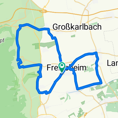
Pfalztour Tag 1
A cycling route starting in Freinsheim, Rhineland-Palatinate, Germany.
Overview
About this route
- -:--
- Duration
- 25.7 km
- Distance
- 564 m
- Ascent
- 500 m
- Descent
- ---
- Avg. speed
- ---
- Max. altitude
Route highlights
Points of interest along the route
Point of interest after 1.5 km
Mittelalterlicher Dorfkern mit historischem Rathaus, Stadtmauer und Stadttor. Infos: Freinsheim.de
Point of interest after 5.5 km
Beginn "Saumagenweg"
Point of interest after 6 km
Ende "Saumagenweg"
Point of interest after 8.3 km
Hütte an der Weilach. Ab hier folgen wir dem Wanderweg "GrünWeiß"
Point of interest after 10 km
Ab hier Wanderweg "BlauWeiß"
Point of interest after 10.2 km
Bismarckturm. Ab hier folgen wir dem Wanderweg "Blau"
Point of interest after 10.9 km
Lindemansruhe (Naturfreundehaus). Erste längere Rast nach Aufstieg. Stärkung mit pfälzischer Hausmannskost und Weizenbier! Info: Lindemannsruhe.de
Point of interest after 11.1 km
Ab hier folgen wir dem Wanderweg "BlauWeiß", auch als "BW" (Burgen-Wanderweg" in einem Dreieck gekennzeichnet.
Point of interest after 18.1 km
Burg Battenberg mit Wirtshaus. Weizenbier!
Point of interest after 23.6 km
Burgruine Neuleiningen. Mittelalterliches Dorf mit Stadtmauer.
Continue with Bikemap
Use, edit, or download this cycling route
You would like to ride Pfalztour Tag 1 or customize it for your own trip? Here is what you can do with this Bikemap route:
Free features
- Save this route as favorite or in collections
- Copy & plan your own version of this route
- Sync your route with Garmin or Wahoo
Premium features
Free trial for 3 days, or one-time payment. More about Bikemap Premium.
- Navigate this route on iOS & Android
- Export a GPX / KML file of this route
- Create your custom printout (try it for free)
- Download this route for offline navigation
Discover more Premium features.
Get Bikemap PremiumFrom our community
Other popular routes starting in Freinsheim
- Kleine Runde
- Distance
- 31.4 km
- Ascent
- 221 m
- Descent
- 193 m
- Location
- Freinsheim, Rhineland-Palatinate, Germany
- Freinsheim - Kurpfalzpark
- Distance
- 18.4 km
- Ascent
- 231 m
- Descent
- 54 m
- Location
- Freinsheim, Rhineland-Palatinate, Germany
- Freinsheim 4. Tag
- Distance
- 43.6 km
- Ascent
- 38 m
- Descent
- 41 m
- Location
- Freinsheim, Rhineland-Palatinate, Germany
- Große Laufrunde
- Distance
- 19.7 km
- Ascent
- 260 m
- Descent
- 257 m
- Location
- Freinsheim, Rhineland-Palatinate, Germany
- Weinstraßenradrundweg durch die Urlaubsregion Freinsheim - Weinstraßenradrundweg durch die Urlaubsregion Freinsheim
- Distance
- 22.7 km
- Ascent
- 260 m
- Descent
- 261 m
- Location
- Freinsheim, Rhineland-Palatinate, Germany
- Pfalztour Tag 1
- Distance
- 25.7 km
- Ascent
- 564 m
- Descent
- 500 m
- Location
- Freinsheim, Rhineland-Palatinate, Germany
- Oschelskopftour Deutsche Weinstraße
- Distance
- 31.5 km
- Ascent
- 281 m
- Descent
- 283 m
- Location
- Freinsheim, Rhineland-Palatinate, Germany
- Rund um den Drachenfels
- Distance
- 65.4 km
- Ascent
- 503 m
- Descent
- 534 m
- Location
- Freinsheim, Rhineland-Palatinate, Germany
Open it in the app