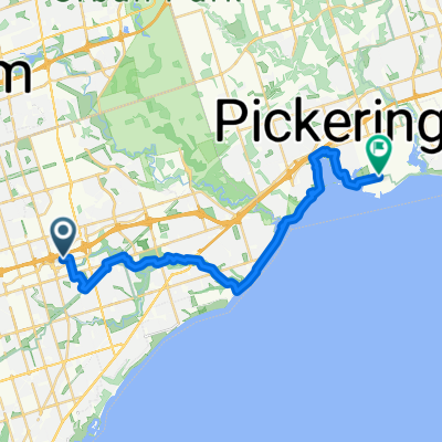
TO35Cycles + Ward 36 Cyclists 2015-December Loop
A cycling route starting in Scarborough, Ontario, Canada.
Overview
About this route
Exploring a new stretch of the Toronto Waterfront east of Ravine Dr via Doris McCarthy Trail
- -:--
- Duration
- 27.5 km
- Distance
- 223 m
- Ascent
- 223 m
- Descent
- ---
- Avg. speed
- ---
- Max. altitude
Route quality
Waytypes & surfaces along the route
Waytypes
Quiet road
13.2 km
(48 %)
Road
3 km
(11 %)
Surfaces
Paved
22 km
(80 %)
Unpaved
4.1 km
(15 %)
Asphalt
21.2 km
(77 %)
Gravel
3.3 km
(12 %)
Route highlights
Points of interest along the route
Point of interest after 3.3 km
Join the Waterfront Trail at Kingston-Warden
Point of interest after 5 km
Really big, empty, glass house.
Point of interest after 8.2 km
Off-road segment - serious mud
Point of interest after 12 km
Top of the Doris McCarthy Trail - rough descent to the lake via Gates Gully
Point of interest after 13.1 km
Passage - by Marlene Hilton Moore - sculpture in iron
Continue with Bikemap
Use, edit, or download this cycling route
You would like to ride TO35Cycles + Ward 36 Cyclists 2015-December Loop or customize it for your own trip? Here is what you can do with this Bikemap route:
Free features
- Save this route as favorite or in collections
- Copy & plan your own version of this route
- Sync your route with Garmin or Wahoo
Premium features
Free trial for 3 days, or one-time payment. More about Bikemap Premium.
- Navigate this route on iOS & Android
- Export a GPX / KML file of this route
- Create your custom printout (try it for free)
- Download this route for offline navigation
Discover more Premium features.
Get Bikemap PremiumFrom our community
Other popular routes starting in Scarborough
 Biking Line 2
- Distance
- 28.3 km
- Ascent
- 195 m
- Descent
- 235 m
- Location
- Scarborough, Ontario, Canada
 Phase 1
- Distance
- 307.8 km
- Ascent
- 1,446 m
- Descent
- 1,526 m
- Location
- Scarborough, Ontario, Canada
 Scarborough to Oshawa via Toronto
- Distance
- 83.1 km
- Ascent
- 420 m
- Descent
- 481 m
- Location
- Scarborough, Ontario, Canada
 Port Union Waterfront Trail
- Distance
- 26.4 km
- Ascent
- 217 m
- Descent
- 284 m
- Location
- Scarborough, Ontario, Canada
 Bendale Park Tr, Toronto to Gaiety Dr, Toronto
- Distance
- 14.8 km
- Ascent
- 106 m
- Descent
- 103 m
- Location
- Scarborough, Ontario, Canada
 Gatineau Hydro Corridor Tr, Toronto to Fitzgibbon Ave, Toronto
- Distance
- 9.1 km
- Ascent
- 39 m
- Descent
- 48 m
- Location
- Scarborough, Ontario, Canada
 Crockford Blvd, Toronto to Fitzgibbon Ave, Toronto
- Distance
- 7.1 km
- Ascent
- 16 m
- Descent
- 19 m
- Location
- Scarborough, Ontario, Canada
 Scarborough-Orangeville Loop
- Distance
- 167.3 km
- Ascent
- 523 m
- Descent
- 523 m
- Location
- Scarborough, Ontario, Canada
Open it in the app


