

The Oxton Gala Loop
A cycling route starting in Lauder, Scotland, United Kingdom.
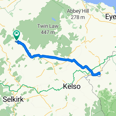
Overview
About this route
Starting off on the abandonned railway line you work your way via Crtleferry Farm to Fountainhall where you join the Old Stage road thru Stow and ontto Clovenfords..then along to Galashiels and the climb back up via Langshaw, eventually drops you back into Lauder- from there a road sprint along the A68 back to Oxton and a cup of tea.
- -:--
- Duration
- 59.4 km
- Distance
- 539 m
- Ascent
- 532 m
- Descent
- ---
- Avg. speed
- ---
- Max. altitude

Continue with Bikemap
Use, edit, or download this cycling route
You would like to ride The Oxton Gala Loop or customize it for your own trip? Here is what you can do with this Bikemap route:
Free features
- Save this route as favorite or in collections
- Copy & plan your own version of this route
- Sync your route with Garmin or Wahoo
Premium features
Free trial for 3 days, or one-time payment. More about Bikemap Premium.
- Navigate this route on iOS & Android
- Export a GPX / KML file of this route
- Create your custom printout (try it for free)
- Download this route for offline navigation
Discover more Premium features.
Get Bikemap PremiumFrom our community
Other popular routes starting in Lauder
 April Inners loop
- Distance
- 88.6 km
- Ascent
- 707 m
- Descent
- 708 m
- Location
- Lauder, Scotland, United Kingdom
 To England and Back to Oxton. Scotland
- Distance
- 93.7 km
- Ascent
- 459 m
- Descent
- 454 m
- Location
- Lauder, Scotland, United Kingdom
 Local Sutra Loop
- Distance
- 23.9 km
- Ascent
- 439 m
- Descent
- 443 m
- Location
- Lauder, Scotland, United Kingdom
 Finding a way through to Innerleithen from Fountainhall..not easy !
- Distance
- 39.6 km
- Ascent
- 568 m
- Descent
- 573 m
- Location
- Lauder, Scotland, United Kingdom
 Hills with Eddy en Route..
- Distance
- 99.9 km
- Ascent
- 753 m
- Descent
- 654 m
- Location
- Lauder, Scotland, United Kingdom
 Around the block thru Fountainhall and Stow.
- Distance
- 44.7 km
- Ascent
- 485 m
- Descent
- 485 m
- Location
- Lauder, Scotland, United Kingdom
 Southern Upland heading east towards Longformacus
- Distance
- 89.1 km
- Ascent
- 894 m
- Descent
- 845 m
- Location
- Lauder, Scotland, United Kingdom
 MTB ride for GTB 67m Over Lammermuirs
- Distance
- 107.1 km
- Ascent
- 508 m
- Descent
- 666 m
- Location
- Lauder, Scotland, United Kingdom
Open it in the app