

Giro dei ponti-Turbigo,tibetano, Molino e Oleggio
A cycling route starting in Cuggiono, Lombardy, Italy.
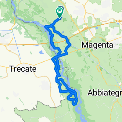
Overview
About this route
From Castelletto di Cuggiono, you follow the canal for a short stretch, then at Cascina Sapuina, you turn towards Cascina Gallarata. Shortly after, you enter the beech forest and subsequently the American forest to emerge at the iron bridge of Turbigo. You climb alongside the Ticino up to the Tibetan bridge, then you cut towards Molino del ponte to then ascend the canal up to the bridge of Oleggio. After crossing it, you descend along the Ticino, and after a detour towards Molino Vecchio, you rise up the valley to the viewpoint of Cameri, following the forest you pass the Ticino again at the bridge of Turbigo to return towards Cuggiono.
- -:--
- Duration
- 44.2 km
- Distance
- 98 m
- Ascent
- 76 m
- Descent
- ---
- Avg. speed
- ---
- Max. altitude
Route quality
Waytypes & surfaces along the route
Waytypes
Track
19.5 km
(44 %)
Path
11.1 km
(25 %)
Surfaces
Paved
10.6 km
(24 %)
Unpaved
19.9 km
(45 %)
Asphalt
10.2 km
(23 %)
Ground
6.6 km
(15 %)
Continue with Bikemap
Use, edit, or download this cycling route
You would like to ride Giro dei ponti-Turbigo,tibetano, Molino e Oleggio or customize it for your own trip? Here is what you can do with this Bikemap route:
Free features
- Save this route as favorite or in collections
- Copy & plan your own version of this route
- Sync your route with Garmin or Wahoo
Premium features
Free trial for 3 days, or one-time payment. More about Bikemap Premium.
- Navigate this route on iOS & Android
- Export a GPX / KML file of this route
- Create your custom printout (try it for free)
- Download this route for offline navigation
Discover more Premium features.
Get Bikemap PremiumFrom our community
Other popular routes starting in Cuggiono
 Cuggiono Abbiategrasso
- Distance
- 35.7 km
- Ascent
- 484 m
- Descent
- 499 m
- Location
- Cuggiono, Lombardy, Italy
 Cuggiono Molino S giacomo Boffalora Cuggiono
- Distance
- 46.1 km
- Ascent
- 116 m
- Descent
- 117 m
- Location
- Cuggiono, Lombardy, Italy
 Giro a velocità lenta in Magenta
- Distance
- 8.5 km
- Ascent
- 49 m
- Descent
- 66 m
- Location
- Cuggiono, Lombardy, Italy
 Parco La Fagiana - da Cuggiono
- Distance
- 29.1 km
- Ascent
- 77 m
- Descent
- 77 m
- Location
- Cuggiono, Lombardy, Italy
 secondo
- Distance
- 12.1 km
- Ascent
- 80 m
- Descent
- 127 m
- Location
- Cuggiono, Lombardy, Italy
 Ticino 50km
- Distance
- 50.5 km
- Ascent
- 163 m
- Descent
- 164 m
- Location
- Cuggiono, Lombardy, Italy
 Cuggiono anello dei due ponti
- Distance
- 37 km
- Ascent
- 101 m
- Descent
- 99 m
- Location
- Cuggiono, Lombardy, Italy
 cuggiono laghi sab ghia cuggiono
- Distance
- 50.4 km
- Ascent
- 121 m
- Descent
- 122 m
- Location
- Cuggiono, Lombardy, Italy
Open it in the app