

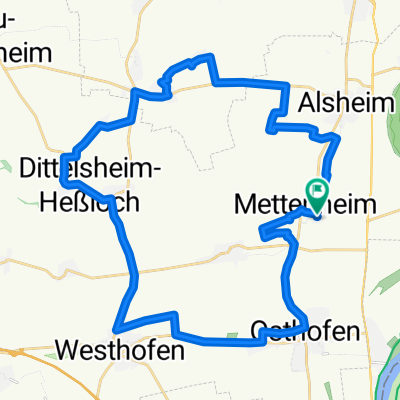
mf66_höllenbrand-monzernheim
A cycling route starting in Mettenheim, Rhineland-Palatinate, Germany.
Overview
About this route
21.12.15, 10:26
- 1 h 26 min
- Duration
- 25.5 km
- Distance
- 266 m
- Ascent
- 266 m
- Descent
- 17.9 km/h
- Avg. speed
- ---
- Max. altitude
Route quality
Waytypes & surfaces along the route
Waytypes
Track
13.5 km
(53 %)
Quiet road
2.8 km
(11 %)
Surfaces
Paved
22.2 km
(87 %)
Unpaved
1 km
(4 %)
Asphalt
11 km
(43 %)
Concrete
6.1 km
(24 %)
Continue with Bikemap
Use, edit, or download this cycling route
You would like to ride mf66_höllenbrand-monzernheim or customize it for your own trip? Here is what you can do with this Bikemap route:
Free features
- Save this route as favorite or in collections
- Copy & plan your own version of this route
- Sync your route with Garmin or Wahoo
Premium features
Free trial for 3 days, or one-time payment. More about Bikemap Premium.
- Navigate this route on iOS & Android
- Export a GPX / KML file of this route
- Create your custom printout (try it for free)
- Download this route for offline navigation
Discover more Premium features.
Get Bikemap PremiumFrom our community
Other popular routes starting in Mettenheim
 mf_Lindemannsruh20150906
- Distance
- 95.6 km
- Ascent
- 527 m
- Descent
- 523 m
- Location
- Mettenheim, Rhineland-Palatinate, Germany
 Am Goldbach 24, Mettenheim nach Am Goldbach 24, Mettenheim
- Distance
- 23.3 km
- Ascent
- 14 m
- Descent
- 18 m
- Location
- Mettenheim, Rhineland-Palatinate, Germany
 Ludwig-Uhland-Straße 4, Mettenheim nach Ludwig-Uhland-Straße 9, Mettenheim
- Distance
- 32.1 km
- Ascent
- 17 m
- Descent
- 19 m
- Location
- Mettenheim, Rhineland-Palatinate, Germany
 Bikenbach2022
- Distance
- 50.6 km
- Ascent
- 68 m
- Descent
- 73 m
- Location
- Mettenheim, Rhineland-Palatinate, Germany
 mf_X-ettenheim-hiwwelsweg20150824
- Distance
- 45.5 km
- Ascent
- 412 m
- Descent
- 412 m
- Location
- Mettenheim, Rhineland-Palatinate, Germany
 mf66_rhh-raufrunter
- Distance
- 52.4 km
- Ascent
- 360 m
- Descent
- 359 m
- Location
- Mettenheim, Rhineland-Palatinate, Germany
 mf66-rgein-nierstein
- Distance
- 70.4 km
- Ascent
- 407 m
- Descent
- 408 m
- Location
- Mettenheim, Rhineland-Palatinate, Germany
 mf66_20160108_1h53min-tour
- Distance
- 35.4 km
- Ascent
- 283 m
- Descent
- 283 m
- Location
- Mettenheim, Rhineland-Palatinate, Germany
Open it in the app