

grosseto FS-scansano-saturnia
A cycling route starting in Grosseto, Tuscany, Italy.
Overview
About this route
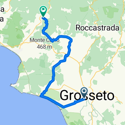
From the Grosseto station, one can reach Istia d'Ombrone. Continue on the SP Scansanese, which is then left to take the right onto Strada Piagge del Maiano, which, after about 5 km flat, becomes a dirt road uphill until the Montorgiale junction. One gets back on the SP Scansanese (unless deviating to the secondary road for Pancole) and arrives at Scansano. Continue left on the SP 160, which is then left to take a dirt road to the left until finding the municipal road del Seragiolo. After a couple of kilometers, it emerges onto the SP 160 Amiatina until Murci (the route follows some dirt or secondary sections). From Murci, continue right on the Strada del Casalone (dirt road in the second part) until proceeding straight on the Strada Comunale del Martelletto. After crossing the Fiascone stream, the SP 112 Usi is encountered, which is taken straight. After about 7 km, a dirt road is found on the right that leads gently uphill to the Strada Provinciale della Follonata. Another about 1 km of climbing and you reach Saturnia.
- -:--
- Duration
- 58.3 km
- Distance
- 1,008 m
- Ascent
- 727 m
- Descent
- ---
- Avg. speed
- ---
- Max. altitude
Route quality
Waytypes & surfaces along the route
Waytypes
Track
19.2 km
(33 %)
Quiet road
16.9 km
(29 %)
Surfaces
Paved
23.3 km
(40 %)
Unpaved
15.2 km
(26 %)
Asphalt
22.1 km
(38 %)
Gravel
9.9 km
(17 %)
Continue with Bikemap
Use, edit, or download this cycling route
You would like to ride grosseto FS-scansano-saturnia or customize it for your own trip? Here is what you can do with this Bikemap route:
Free features
- Save this route as favorite or in collections
- Copy & plan your own version of this route
- Sync your route with Garmin or Wahoo
Premium features
Free trial for 3 days, or one-time payment. More about Bikemap Premium.
- Navigate this route on iOS & Android
- Export a GPX / KML file of this route
- Create your custom printout (try it for free)
- Download this route for offline navigation
Discover more Premium features.
Get Bikemap PremiumFrom our community
Other popular routes starting in Grosseto
 Via Podgora 66, Grosseto nach Via Podgora 66, Grosseto
- Distance
- 417.9 km
- Ascent
- 10 m
- Descent
- 10 m
- Location
- Grosseto, Tuscany, Italy
 Viale della Repubblica 2/ASNC to Via Guglielmo Marconi
- Distance
- 77.4 km
- Ascent
- 964 m
- Descent
- 567 m
- Location
- Grosseto, Tuscany, Italy
 Grosseto => Orbetello Scalo
- Distance
- 68.5 km
- Ascent
- 106 m
- Descent
- 115 m
- Location
- Grosseto, Tuscany, Italy
 marina di grosseto bis piombino CLONED FROM ROUTE 658973
- Distance
- 66.4 km
- Ascent
- 220 m
- Descent
- 220 m
- Location
- Grosseto, Tuscany, Italy
 SSC Grosseto NW 117 km
- Distance
- 117.1 km
- Ascent
- 1,239 m
- Descent
- 1,240 m
- Location
- Grosseto, Tuscany, Italy
 Giro d'Italia 2015 - Stage 7
- Distance
- 268.4 km
- Ascent
- 1,601 m
- Descent
- 992 m
- Location
- Grosseto, Tuscany, Italy
 SSC Grosseto/Toscana '13: Tour 3 '90 km südl. von Grosseto'
- Distance
- 91.7 km
- Ascent
- 692 m
- Descent
- 694 m
- Location
- Grosseto, Tuscany, Italy
 Grosseto-Vetulonia-Caldana-Gavorrano-Massa
- Distance
- 56.6 km
- Ascent
- 898 m
- Descent
- 615 m
- Location
- Grosseto, Tuscany, Italy
Open it in the app