

Jonastal
A cycling route starting in Geraberg, Thuringia, Germany.
Overview
About this route
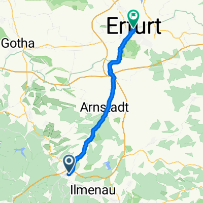
Arnstadt - Plaue - Geraberg - Gräfenroda - Crawinkel - Arnstadt
- -:--
- Duration
- 43 km
- Distance
- 454 m
- Ascent
- 454 m
- Descent
- ---
- Avg. speed
- ---
- Max. altitude
Route quality
Waytypes & surfaces along the route
Waytypes
Road
14.6 km
(34 %)
Quiet road
10.3 km
(24 %)
Surfaces
Paved
40.9 km
(95 %)
Asphalt
40.4 km
(94 %)
Paved (undefined)
0.4 km
(1 %)
Undefined
2.2 km
(5 %)
Continue with Bikemap
Use, edit, or download this cycling route
You would like to ride Jonastal or customize it for your own trip? Here is what you can do with this Bikemap route:
Free features
- Save this route as favorite or in collections
- Copy & plan your own version of this route
- Sync your route with Garmin or Wahoo
Premium features
Free trial for 3 days, or one-time payment. More about Bikemap Premium.
- Navigate this route on iOS & Android
- Export a GPX / KML file of this route
- Create your custom printout (try it for free)
- Download this route for offline navigation
Discover more Premium features.
Get Bikemap PremiumFrom our community
Other popular routes starting in Geraberg
 Dillstädt-Skihang Schmiedefeld-Schneekopf-Gehlberger Grund-Schneekopf-Zahme Gera-Mönchshof-Mordfleck-Wegscheide (Teil 4)
- Distance
- 20.4 km
- Ascent
- 667 m
- Descent
- 312 m
- Location
- Geraberg, Thuringia, Germany
 Rennsteig Etappe 2
- Distance
- 108.7 km
- Ascent
- 1,169 m
- Descent
- 1,171 m
- Location
- Geraberg, Thuringia, Germany
 Jonastal
- Distance
- 43 km
- Ascent
- 454 m
- Descent
- 454 m
- Location
- Geraberg, Thuringia, Germany
 Geraberg Schneekopf
- Distance
- 18.4 km
- Ascent
- 655 m
- Descent
- 164 m
- Location
- Geraberg, Thuringia, Germany
 Geraberg-Steintal-Stützerbach-Ilmenau
- Distance
- 26 km
- Ascent
- 611 m
- Descent
- 494 m
- Location
- Geraberg, Thuringia, Germany
 MNG 03 - OBHO - EF
- Distance
- 37.6 km
- Ascent
- 67 m
- Descent
- 292 m
- Location
- Geraberg, Thuringia, Germany
 Jüchnitz/ Mönchhof
- Distance
- 8.3 km
- Ascent
- 557 m
- Descent
- 251 m
- Location
- Geraberg, Thuringia, Germany
 Geraberg-Schorte Ilmenau
- Distance
- 14.2 km
- Ascent
- 639 m
- Descent
- 563 m
- Location
- Geraberg, Thuringia, Germany
Open it in the app