
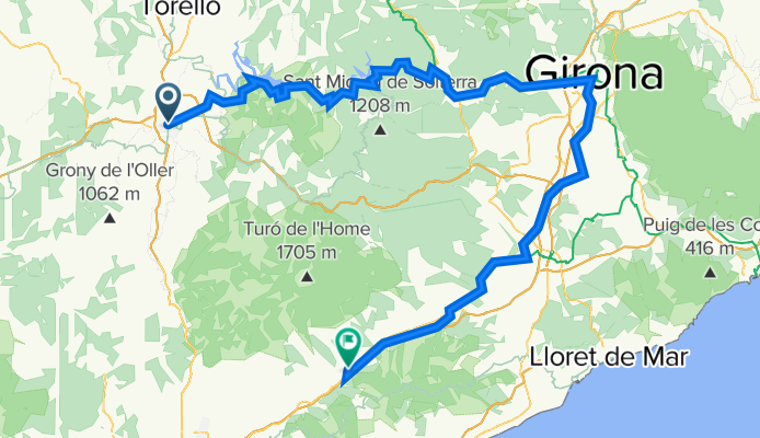
Vic-Pantà de Sau i Susqueda-Girona-Sant Celoni
A cycling route starting in Vic, Catalonia, Spain.
Overview
About this route
Salida de Vic en dirección al la pista que bordea los pantanos de Sau y Susqueda, a veces pista de tierra, a veces pista asfaltada al principio. La subida más larga está al principio de la ruta y es muy suave, después son subes y bajas que te van rompiendo las piernas si no te lo tomas con calma. Si ha llovido habrá alguna zona enbarrada, que será la mayor complicación de la ruta, porque el resto es ciclable 100%. Antes de llegar a Girona se enlaza con la Ruta del Carrilet, y al pasar Girona enlazamos con la Ruta Vía Augusta pasando por poligonos industriales, carreteras secundarias, y pistas sencillas más o menos estrechas hasta llegar a Hoatalric, después de Hostalric hasta Sant Celoni, vamos bordeando la AP7 por una pista.
- -:--
- Duration
- 129 km
- Distance
- 493 m
- Ascent
- 835 m
- Descent
- ---
- Avg. speed
- ---
- Avg. speed

Route quality
Waytypes & surfaces along the route
Waytypes
Track
49.2 km
(38 %)
Quiet road
32.8 km
(25 %)
Surfaces
Paved
46.4 km
(36 %)
Unpaved
30 km
(23 %)
Asphalt
34.1 km
(26 %)
Gravel
14.9 km
(12 %)
Continue with Bikemap
Use, edit, or download this cycling route
You would like to ride Vic-Pantà de Sau i Susqueda-Girona-Sant Celoni or customize it for your own trip? Here is what you can do with this Bikemap route:
Free features
- Save this route as favorite or in collections
- Copy & plan your own version of this route
- Sync your route with Garmin or Wahoo
Premium features
Free trial for 3 days, or one-time payment. More about Bikemap Premium.
- Navigate this route on iOS & Android
- Export a GPX / KML file of this route
- Create your custom printout (try it for free)
- Download this route for offline navigation
Discover more Premium features.
Get Bikemap PremiumFrom our community
Other popular routes starting in Vic
 Vic to Olot
- Distance
- 60.7 km
- Ascent
- 836 m
- Descent
- 904 m
- Location
- Vic, Catalonia, Spain
 Entorn Gurri retorn
- Distance
- 6.4 km
- Ascent
- 29 m
- Descent
- 26 m
- Location
- Vic, Catalonia, Spain
 Rius Folgueroles Ruta dels Molins
- Distance
- 22.8 km
- Ascent
- 146 m
- Descent
- 147 m
- Location
- Vic, Catalonia, Spain
 Vic - Vic (Jordi Tao - Els caminets d'en Tao)
- Distance
- 29.3 km
- Ascent
- 221 m
- Descent
- 221 m
- Location
- Vic, Catalonia, Spain
 Sortida VIC-BRACONS
- Distance
- 100.2 km
- Ascent
- 1,442 m
- Descent
- 1,442 m
- Location
- Vic, Catalonia, Spain
 JUFRÉ- CICLOTURISME-sortida-1
- Distance
- 52.9 km
- Ascent
- 661 m
- Descent
- 661 m
- Location
- Vic, Catalonia, Spain
 Vic - Manresa - Autonoma
- Distance
- 143.4 km
- Ascent
- 3,291 m
- Descent
- 3,677 m
- Location
- Vic, Catalonia, Spain
 ruta molins fariners
- Distance
- 7 km
- Ascent
- 89 m
- Descent
- 92 m
- Location
- Vic, Catalonia, Spain
Open it in the app