

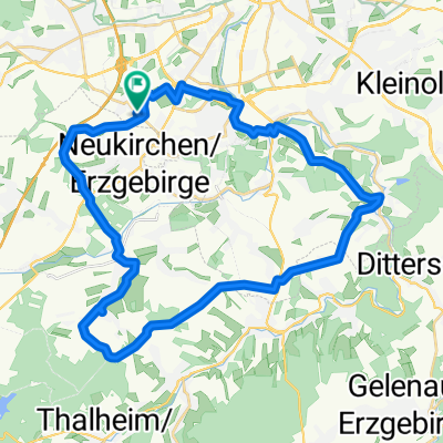
Himmelfahrt 2016, Strecke rückwärts
A cycling route starting in Neukirchen, Saxony, Germany.
Overview
About this route
This route was walked in 2016 during Ascension.
On this day, the bike stays at home, because there are enough days in the year when one can ride a bike!
- -:--
- Duration
- 11.9 km
- Distance
- 164 m
- Ascent
- 164 m
- Descent
- ---
- Avg. speed
- ---
- Max. altitude

Route quality
Waytypes & surfaces along the route
Waytypes
Quiet road
5.7 km
(48 %)
Path
2.1 km
(18 %)
Surfaces
Paved
7.9 km
(66 %)
Unpaved
1.7 km
(14 %)
Asphalt
7.6 km
(64 %)
Gravel
0.7 km
(6 %)
Continue with Bikemap
Use, edit, or download this cycling route
You would like to ride Himmelfahrt 2016, Strecke rückwärts or customize it for your own trip? Here is what you can do with this Bikemap route:
Free features
- Save this route as favorite or in collections
- Copy & plan your own version of this route
- Sync your route with Garmin or Wahoo
Premium features
Free trial for 3 days, or one-time payment. More about Bikemap Premium.
- Navigate this route on iOS & Android
- Export a GPX / KML file of this route
- Create your custom printout (try it for free)
- Download this route for offline navigation
Discover more Premium features.
Get Bikemap PremiumFrom our community
Other popular routes starting in Neukirchen
 Wasserschloßweg nach Chemnitz Kulturhauptstadt Europa 2025
- Distance
- 30.7 km
- Ascent
- 423 m
- Descent
- 423 m
- Location
- Neukirchen, Saxony, Germany
 Wasserschloßweg, Chemnitz nach An der Markthalle, Chemnitz
- Distance
- 19 km
- Ascent
- 244 m
- Descent
- 282 m
- Location
- Neukirchen, Saxony, Germany
 Neukirchen - Lugau - Neukirchen
- Distance
- 28.1 km
- Ascent
- 197 m
- Descent
- 193 m
- Location
- Neukirchen, Saxony, Germany
 Chemnitz - Südböhmen - Südmähren
- Distance
- 844.3 km
- Ascent
- 2,001 m
- Descent
- 2,130 m
- Location
- Neukirchen, Saxony, Germany
 Chemnitz-Keilberg-Fichtelberg-Chemnitz
- Distance
- 119.9 km
- Ascent
- 1,362 m
- Descent
- 1,362 m
- Location
- Neukirchen, Saxony, Germany
 Erzgebirgstour
- Distance
- 96.5 km
- Ascent
- 1,517 m
- Descent
- 1,494 m
- Location
- Neukirchen, Saxony, Germany
 Eisenweg und Pfarrhübel über Eisnsiedel
- Distance
- 35.4 km
- Ascent
- 574 m
- Descent
- 572 m
- Location
- Neukirchen, Saxony, Germany
 Hügelige Runde bei Chemnitz
- Distance
- 34.1 km
- Ascent
- 717 m
- Descent
- 714 m
- Location
- Neukirchen, Saxony, Germany
Open it in the app