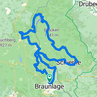
Brockentour-42.5km 2015-12-29
A cycling route starting in Braunlage, Lower Saxony, Germany.
Overview
About this route
Gefahren am 29.12.2015, bei unglaulichem Wetter zu dieser Jahreszeit, trocken, sonnig, oben windig ca. 2 bis 6°C. Hab die Tour Lemmy Gedächnistour genannt (Lemmy Kilmister - Motörhead 24.12.1945 - 28.12.2015).
Ich selbst fahre ein 28"Crossbike, womit sich die Tour bis auf wenige Ausnahmen sehr gut fahren ließ, also mehr Mountainbike als Sport-/Rennradtour. Der Parkplatz in Schierke (Start/Ziel) kostet moderate 3,00€/Tag. Schierke 600m-Brocken 1142m-Eckertalsperre 620m-Torfhaus 800m-Richtung Brocken 900m-entlang der Kalten Bode bis Schierke 600m.- -:--
- Duration
- 41.6 km
- Distance
- 911 m
- Ascent
- 910 m
- Descent
- ---
- Avg. speed
- ---
- Max. altitude
Continue with Bikemap
Use, edit, or download this cycling route
You would like to ride Brockentour-42.5km 2015-12-29 or customize it for your own trip? Here is what you can do with this Bikemap route:
Free features
- Save this route as favorite or in collections
- Copy & plan your own version of this route
- Sync your route with Garmin or Wahoo
Premium features
Free trial for 3 days, or one-time payment. More about Bikemap Premium.
- Navigate this route on iOS & Android
- Export a GPX / KML file of this route
- Create your custom printout (try it for free)
- Download this route for offline navigation
Discover more Premium features.
Get Bikemap PremiumFrom our community
Other popular routes starting in Braunlage
- MTBKS - Braunlage 1
- Distance
- 44.3 km
- Ascent
- 1,157 m
- Descent
- 1,163 m
- Location
- Braunlage, Lower Saxony, Germany
- MTBKS - Braunlage 2
- Distance
- 31 km
- Ascent
- 576 m
- Descent
- 572 m
- Location
- Braunlage, Lower Saxony, Germany
- Braunlage: Trailfeuerwerk!
- Distance
- 44.1 km
- Ascent
- 847 m
- Descent
- 858 m
- Location
- Braunlage, Lower Saxony, Germany
- Braunlage Eckerstausee
- Distance
- 38.7 km
- Ascent
- 905 m
- Descent
- 904 m
- Location
- Braunlage, Lower Saxony, Germany
- 1. Harzer Runde 0509
- Distance
- 56.3 km
- Ascent
- 953 m
- Descent
- 960 m
- Location
- Braunlage, Lower Saxony, Germany
- Elend-Trail
- Distance
- 16.5 km
- Ascent
- 316 m
- Descent
- 316 m
- Location
- Braunlage, Lower Saxony, Germany
- Braunlage: Eingewöhnungsrunde
- Distance
- 16.2 km
- Ascent
- 283 m
- Descent
- 300 m
- Location
- Braunlage, Lower Saxony, Germany
- Braunlage - Königshütte - Brocken - Zorge - Braunlage
- Distance
- 94.5 km
- Ascent
- 1,348 m
- Descent
- 1,395 m
- Location
- Braunlage, Lower Saxony, Germany
Open it in the app