

trainingsrunde3
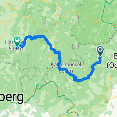
A cycling route starting in Mudau, Baden-Wurttemberg, Germany.
Overview
About this route
Easy training since the climbs are paved.
- -:--
- Duration
- 24.6 km
- Distance
- 509 m
- Ascent
- 497 m
- Descent
- ---
- Avg. speed
- ---
- Max. altitude
Route quality
Waytypes & surfaces along the route
Waytypes
Track
10.1 km
(41 %)
Quiet road
7.4 km
(30 %)
Surfaces
Paved
14.3 km
(58 %)
Unpaved
8.6 km
(35 %)
Asphalt
12.6 km
(51 %)
Gravel
8.1 km
(33 %)
Continue with Bikemap
Use, edit, or download this cycling route
You would like to ride trainingsrunde3 or customize it for your own trip? Here is what you can do with this Bikemap route:
Free features
- Save this route as favorite or in collections
- Copy & plan your own version of this route
- Sync your route with Garmin or Wahoo
Premium features
Free trial for 3 days, or one-time payment. More about Bikemap Premium.
- Navigate this route on iOS & Android
- Export a GPX / KML file of this route
- Create your custom printout (try it for free)
- Download this route for offline navigation
Discover more Premium features.
Get Bikemap PremiumFrom our community
Other popular routes starting in Mudau
 20130808_Mudau nach Roßdorf
- Distance
- 139.1 km
- Ascent
- 668 m
- Descent
- 923 m
- Location
- Mudau, Baden-Wurttemberg, Germany
 Mudau-Steinbach-Beuchen-Mudau über St3
- Distance
- 17.8 km
- Ascent
- 231 m
- Descent
- 231 m
- Location
- Mudau, Baden-Wurttemberg, Germany
 Limes- Niebelubgensteig
- Distance
- 36.6 km
- Ascent
- 1,044 m
- Descent
- 1,045 m
- Location
- Mudau, Baden-Wurttemberg, Germany
 Mudau-Gaimühle-Sensbacher Höhe -Beerfelden -Wald-Michelbach
- Distance
- 53.3 km
- Ascent
- 655 m
- Descent
- 779 m
- Location
- Mudau, Baden-Wurttemberg, Germany
 Rund um Mudau
- Distance
- 41.9 km
- Ascent
- 438 m
- Descent
- 436 m
- Location
- Mudau, Baden-Wurttemberg, Germany
 20130805_3-Länder-Rad-Event_Tag 1
- Distance
- 57 km
- Ascent
- 776 m
- Descent
- 767 m
- Location
- Mudau, Baden-Wurttemberg, Germany
 Tandem WE 2015 Sonntag
- Distance
- 26.8 km
- Ascent
- 420 m
- Descent
- 412 m
- Location
- Mudau, Baden-Wurttemberg, Germany
 Odenwald mit Höhen und Tiefen
- Distance
- 55.8 km
- Ascent
- 669 m
- Descent
- 669 m
- Location
- Mudau, Baden-Wurttemberg, Germany
Open it in the app