

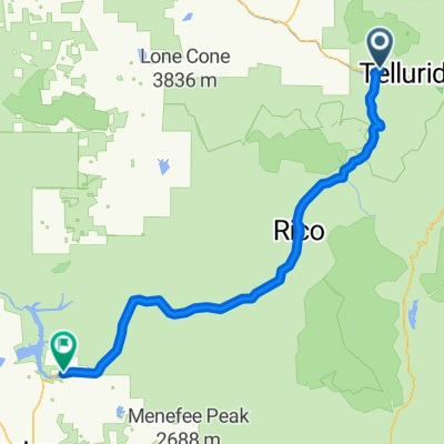
p39 Dallas Divide Pass
A cycling route starting in Mountain Village, Colorado, United States of America.
Overview
About this route
Dallas Divide Pass (2734 m n.p.m. / 8970 ft) Przejechałem 17.05.2015 z Placerville do Ridgway
- -:--
- Duration
- 37.4 km
- Distance
- 513 m
- Ascent
- 605 m
- Descent
- ---
- Avg. speed
- ---
- Max. altitude

Route quality
Waytypes & surfaces along the route
Waytypes
Busy road
32.1 km
(86 %)
Cycleway
2.9 km
(8 %)
Surfaces
Paved
35.2 km
(94 %)
Unpaved
2.2 km
(6 %)
Asphalt
32.1 km
(86 %)
Concrete
2.9 km
(8 %)
Route highlights
Points of interest along the route

Photo after 19.9 km
Dallas Divide Pass (2734 m n.p.m. / 8970 ft) Przejechałem 17.05.2015 z Placerville do Ridgway
Continue with Bikemap
Use, edit, or download this cycling route
You would like to ride p39 Dallas Divide Pass or customize it for your own trip? Here is what you can do with this Bikemap route:
Free features
- Save this route as favorite or in collections
- Copy & plan your own version of this route
- Sync your route with Garmin or Wahoo
Premium features
Free trial for 3 days, or one-time payment. More about Bikemap Premium.
- Navigate this route on iOS & Android
- Export a GPX / KML file of this route
- Create your custom printout (try it for free)
- Download this route for offline navigation
Discover more Premium features.
Get Bikemap PremiumFrom our community
Other popular routes starting in Mountain Village
 3130 Last Dollar Rd, Telluride to 237 S Oak St, Telluride
- Distance
- 12 km
- Ascent
- 188 m
- Descent
- 244 m
- Location
- Mountain Village, Colorado, United States of America
 Rico to Opus Hut
- Distance
- 67.1 km
- Ascent
- 1,955 m
- Descent
- 1,383 m
- Location
- Mountain Village, Colorado, United States of America
 p39 Dallas Divide Pass
- Distance
- 37.4 km
- Ascent
- 513 m
- Descent
- 605 m
- Location
- Mountain Village, Colorado, United States of America
 94–98 Colorado Ave, Telluride to 2805–2985 Last Dollar Rd, Telluride
- Distance
- 6.3 km
- Ascent
- 232 m
- Descent
- 78 m
- Location
- Mountain Village, Colorado, United States of America
 Recovered Route
- Distance
- 0.2 km
- Ascent
- 42 m
- Descent
- 40 m
- Location
- Mountain Village, Colorado, United States of America
 Telluride to Dolores
- Distance
- 98.9 km
- Ascent
- 622 m
- Descent
- 1,140 m
- Location
- Mountain Village, Colorado, United States of America
 Saw Pit, CO - McKenzie Butte, CO
- Distance
- 57.5 km
- Ascent
- 816 m
- Descent
- 835 m
- Location
- Mountain Village, Colorado, United States of America
 Telluride to Ouray
- Distance
- 81.8 km
- Ascent
- 843 m
- Descent
- 1,230 m
- Location
- Mountain Village, Colorado, United States of America
Open it in the app