
A YECHAR POR ALHAMA-EL NIÑO
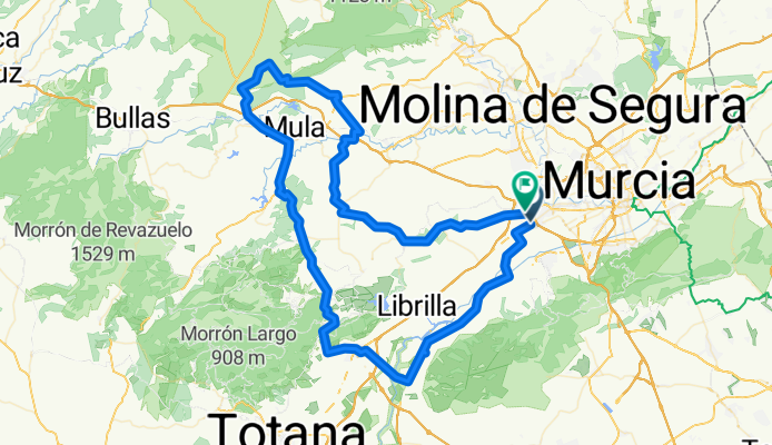
A cycling route starting in Alcantarilla, Murcia, Spain.
Overview
About this route
ALCANTARILLA-COSTERA-ALHAMA-PLIEGO-MULA-EL NIÑO-MONTARAL-FUENTE CAPUTA-YECHAR (REFRESHMENT)-LOS BAÑOS-MINGLANILLO-BARQUEROS-ALCANTARILLA
- -:--
- Duration
- 115.9 km
- Distance
- 940 m
- Ascent
- 931 m
- Descent
- ---
- Avg. speed
- ---
- Max. altitude

Route quality
Waytypes & surfaces along the route
Waytypes
Quiet road
41.7 km
(36 %)
Track
3.5 km
(3 %)
Surfaces
Paved
75.4 km
(65 %)
Unpaved
1.2 km
(1 %)
Asphalt
74.2 km
(64 %)
Paved (undefined)
1.2 km
(1 %)
Route highlights
Points of interest along the route

Point of interest after 32.7 km
COMIENZA PUERTO DE GEBAS
Point of interest after 40.6 km
FIN DE PUERTO
Continue with Bikemap
Use, edit, or download this cycling route
You would like to ride A YECHAR POR ALHAMA-EL NIÑO or customize it for your own trip? Here is what you can do with this Bikemap route:
Free features
- Save this route as favorite or in collections
- Copy & plan your own version of this route
- Split it into stages to create a multi-day tour
- Sync your route with Garmin or Wahoo
Premium features
Free trial for 3 days, or one-time payment. More about Bikemap Premium.
- Navigate this route on iOS & Android
- Export a GPX / KML file of this route
- Create your custom printout (try it for free)
- Download this route for offline navigation
Discover more Premium features.
Get Bikemap PremiumFrom our community
Other popular routes starting in Alcantarilla
 INTEGRAL DE LA CABRA 2010
- Distance
- 69.7 km
- Ascent
- 1,301 m
- Descent
- 1,304 m
- Location
- Alcantarilla, Murcia, Spain
 Salida dia 22/02/14
- Distance
- 106 km
- Ascent
- 364 m
- Descent
- 367 m
- Location
- Alcantarilla, Murcia, Spain
 Salida 25/01/14
- Distance
- 69.3 km
- Ascent
- 495 m
- Descent
- 499 m
- Location
- Alcantarilla, Murcia, Spain
 Salida dia 01/02/14
- Distance
- 118.2 km
- Ascent
- 841 m
- Descent
- 842 m
- Location
- Alcantarilla, Murcia, Spain
 Salida 15/03/14
- Distance
- 92.6 km
- Ascent
- 602 m
- Descent
- 605 m
- Location
- Alcantarilla, Murcia, Spain
 A YECHAR POR ALHAMA-EL NIÑO
- Distance
- 115.9 km
- Ascent
- 940 m
- Descent
- 931 m
- Location
- Alcantarilla, Murcia, Spain
 Salida dia 18/01/14
- Distance
- 116.2 km
- Ascent
- 453 m
- Descent
- 454 m
- Location
- Alcantarilla, Murcia, Spain
 Salida 25/01/14
- Distance
- 69.4 km
- Ascent
- 495 m
- Descent
- 499 m
- Location
- Alcantarilla, Murcia, Spain
Open it in the app