

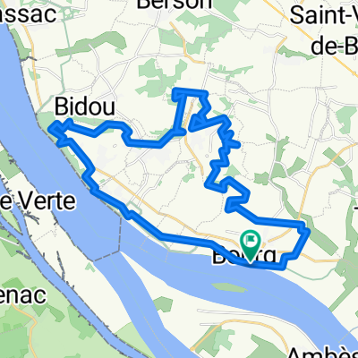
Bordeaux Bike Trip Day 2
A cycling route starting in Bourg, Nouvelle-Aquitaine, France.
Overview
About this route
Lonely Planet
- -:--
- Duration
- 25.1 km
- Distance
- 129 m
- Ascent
- 121 m
- Descent
- ---
- Avg. speed
- ---
- Max. altitude

Route quality
Waytypes & surfaces along the route
Waytypes
Road
13.6 km
(54 %)
Quiet road
4 km
(16 %)
Surfaces
Paved
7.5 km
(30 %)
Asphalt
7.5 km
(30 %)
Undefined
17.6 km
(70 %)
Route highlights
Points of interest along the route
Point of interest after 5.2 km
Grottes de Pair non Pair
Point of interest after 12.5 km
Chateau de Boulieh
Continue with Bikemap
Use, edit, or download this cycling route
You would like to ride Bordeaux Bike Trip Day 2 or customize it for your own trip? Here is what you can do with this Bikemap route:
Free features
- Save this route as favorite or in collections
- Copy & plan your own version of this route
- Sync your route with Garmin or Wahoo
Premium features
Free trial for 3 days, or one-time payment. More about Bikemap Premium.
- Navigate this route on iOS & Android
- Export a GPX / KML file of this route
- Create your custom printout (try it for free)
- Download this route for offline navigation
Discover more Premium features.
Get Bikemap PremiumFrom our community
Other popular routes starting in Bourg
 Bordeaux Bike Trip Day 2
- Distance
- 25.1 km
- Ascent
- 129 m
- Descent
- 121 m
- Location
- Bourg, Nouvelle-Aquitaine, France
 Bourg / Gauriac
- Distance
- 10.2 km
- Ascent
- 81 m
- Descent
- 102 m
- Location
- Bourg, Nouvelle-Aquitaine, France
 Bourg - Royan - La Palmyre
- Distance
- 110.6 km
- Ascent
- 174 m
- Descent
- 176 m
- Location
- Bourg, Nouvelle-Aquitaine, France
 TdF jour 14 (manque 53km pour départ de Camblane)
- Distance
- 69.9 km
- Ascent
- 98 m
- Descent
- 139 m
- Location
- Bourg, Nouvelle-Aquitaine, France
 bourg.gpx
- Distance
- 35.2 km
- Ascent
- 336 m
- Descent
- 335 m
- Location
- Bourg, Nouvelle-Aquitaine, France
 De 122 Impasse du Port, Bayon-sur-Gironde à 13 Rue Saint-Simon, Blaye
- Distance
- 11.9 km
- Ascent
- 3 m
- Descent
- 20 m
- Location
- Bourg, Nouvelle-Aquitaine, France
 dordogne - puy de dome
- Distance
- 531.5 km
- Ascent
- 2,358 m
- Descent
- 929 m
- Location
- Bourg, Nouvelle-Aquitaine, France
 Day 7 Bourg to St. Emillion
- Distance
- 49.7 km
- Ascent
- 281 m
- Descent
- 250 m
- Location
- Bourg, Nouvelle-Aquitaine, France
Open it in the app