

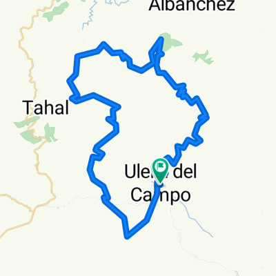
la vuelta al santuario de monteagud
A cycling route starting in Uleila de Campo, Andalusia, Spain.
Overview
About this route
- -:--
- Duration
- 92.2 km
- Distance
- 2,158 m
- Ascent
- 1,917 m
- Descent
- ---
- Avg. speed
- 883 m
- Max. altitude

Route quality
Waytypes & surfaces along the route
Waytypes
Road
76.8 km
(83 %)
Quiet road
9.2 km
(10 %)
Surfaces
Paved
1.3 km
(1 %)
Asphalt
1.3 km
(1 %)
Undefined
90.9 km
(99 %)
Route highlights
Points of interest along the route
Point of interest after 69.2 km
fuente potable para llenar agua
Continue with Bikemap
Use, edit, or download this cycling route
You would like to ride la vuelta al santuario de monteagud or customize it for your own trip? Here is what you can do with this Bikemap route:
Free features
- Save this route as favorite or in collections
- Copy & plan your own version of this route
- Split it into stages to create a multi-day tour
- Sync your route with Garmin or Wahoo
Premium features
Free trial for 3 days, or one-time payment. More about Bikemap Premium.
- Navigate this route on iOS & Android
- Export a GPX / KML file of this route
- Create your custom printout (try it for free)
- Download this route for offline navigation
Discover more Premium features.
Get Bikemap PremiumFrom our community
Other popular routes starting in Uleila de Campo
 Ruta por ULEILA y Ermita Virgen de la Cabeza
- Distance
- 52 km
- Ascent
- 1,324 m
- Descent
- 1,324 m
- Location
- Uleila de Campo, Andalusia, Spain
 Vuelta Cerro Monteagud
- Distance
- 57.3 km
- Ascent
- 1,165 m
- Descent
- 1,158 m
- Location
- Uleila de Campo, Andalusia, Spain
 definitiva btt 2020
- Distance
- 39.5 km
- Ascent
- 324 m
- Descent
- 934 m
- Location
- Uleila de Campo, Andalusia, Spain
 1º mtb uleila 2019 (provisional1)
- Distance
- 36.5 km
- Ascent
- 601 m
- Descent
- 600 m
- Location
- Uleila de Campo, Andalusia, Spain
 DEFINITIVO MTB 2020 ULEILA
- Distance
- 41.3 km
- Ascent
- 588 m
- Descent
- 586 m
- Location
- Uleila de Campo, Andalusia, Spain
 la vuelta al santuario de monteagud
- Distance
- 92.2 km
- Ascent
- 2,158 m
- Descent
- 1,917 m
- Location
- Uleila de Campo, Andalusia, Spain
 Uleila, Ermita
- Distance
- 20.2 km
- Ascent
- 680 m
- Descent
- 680 m
- Location
- Uleila de Campo, Andalusia, Spain
 03 Uleila del Campo-Benizalón
- Distance
- 19 km
- Ascent
- 650 m
- Descent
- 327 m
- Location
- Uleila de Campo, Andalusia, Spain
Open it in the app