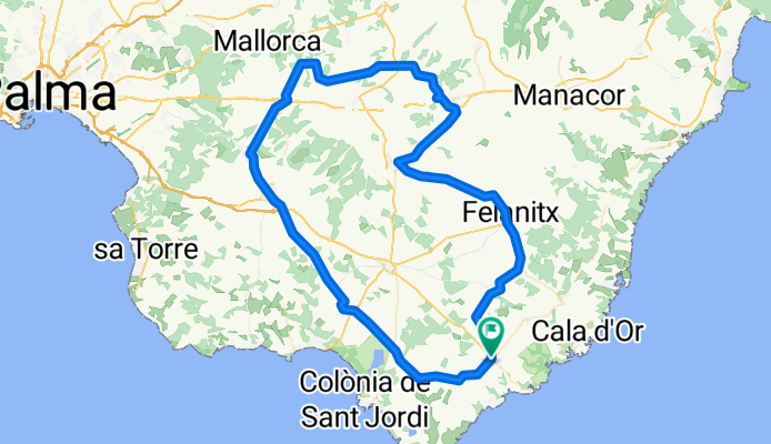
FELANITX-PORRERES-VILAFRANCA-ELS CALDERERS-PINA-CAMI MUNTANYA-SON MARRANO-SES SALINES
A cycling route starting in Santanyí, Balearic Islands, Spain.
Overview
About this route
CLUB CICLISTA SANTANYÍ
- -:--
- Duration
- 102.4 km
- Distance
- 419 m
- Ascent
- 418 m
- Descent
- ---
- Avg. speed
- ---
- Avg. speed
Route quality
Waytypes & surfaces along the route
Waytypes
Busy road
35.6 km
(35 %)
Road
34.4 km
(34 %)
Surfaces
Paved
70.1 km
(68 %)
Asphalt
69.8 km
(68 %)
Paving stones
0.3 km
(<1 %)
Undefined
32.3 km
(32 %)
Continue with Bikemap
Use, edit, or download this cycling route
You would like to ride FELANITX-PORRERES-VILAFRANCA-ELS CALDERERS-PINA-CAMI MUNTANYA-SON MARRANO-SES SALINES or customize it for your own trip? Here is what you can do with this Bikemap route:
Free features
- Save this route as favorite or in collections
- Copy & plan your own version of this route
- Sync your route with Garmin or Wahoo
Premium features
Free trial for 3 days, or one-time payment. More about Bikemap Premium.
- Navigate this route on iOS & Android
- Export a GPX / KML file of this route
- Create your custom printout (try it for free)
- Download this route for offline navigation
Discover more Premium features.
Get Bikemap PremiumFrom our community
Other popular routes starting in Santanyí
- Santanyi 2010
- Distance
- 57.8 km
- Ascent
- 623 m
- Descent
- 623 m
- Location
- Santanyí, Balearic Islands, Spain
- Santanyi_ueber_zwei_Berge
- Distance
- 67.4 km
- Ascent
- 1,038 m
- Descent
- 965 m
- Location
- Santanyí, Balearic Islands, Spain
- Pojecta 1
- Distance
- 15 km
- Ascent
- 681 m
- Descent
- 680 m
- Location
- Santanyí, Balearic Islands, Spain
- FELANITX-PORRERES-VILAFRANCA-ELS CALDERERS-PINA-CAMI MUNTANYA-SON MARRANO-SES SALINES
- Distance
- 102.4 km
- Ascent
- 419 m
- Descent
- 418 m
- Location
- Santanyí, Balearic Islands, Spain
- Santanyí-Biniali-Algaida-Llucmajor-Santanyí
- Distance
- 106.4 km
- Ascent
- 410 m
- Descent
- 426 m
- Location
- Santanyí, Balearic Islands, Spain
- 11.03 Campos Sa sorda
- Distance
- 54.6 km
- Ascent
- 243 m
- Descent
- 241 m
- Location
- Santanyí, Balearic Islands, Spain
- Cala Santanyi-Cas Concos-Alqueria Blanca-Cala Santanyi
- Distance
- 37.5 km
- Ascent
- 187 m
- Descent
- 186 m
- Location
- Santanyí, Balearic Islands, Spain
- MONTISION-CURA-SANT MIQUEL-BONANY-SANT SALVADOR
- Distance
- 128.5 km
- Ascent
- 1,222 m
- Descent
- 1,222 m
- Location
- Santanyí, Balearic Islands, Spain