

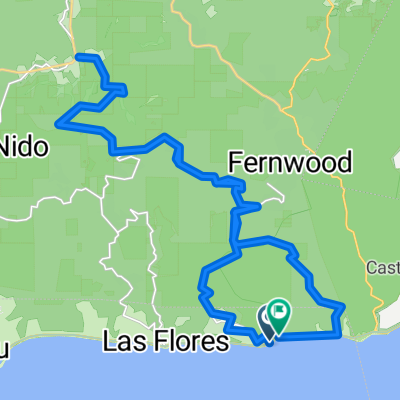
topanga
A cycling route starting in Las Flores, California, United States.
Overview
About this route
sgdhfsn
- -:--
- Duration
- 53.2 km
- Distance
- 992 m
- Ascent
- 987 m
- Descent
- ---
- Avg. speed
- ---
- Max. altitude
Route quality
Waytypes & surfaces along the route
Waytypes
Road
18.6 km
(35 %)
Cycleway
12.2 km
(23 %)
Surfaces
Paved
31.9 km
(60 %)
Asphalt
29.8 km
(56 %)
Concrete
2.1 km
(4 %)
Undefined
21.3 km
(40 %)
Continue with Bikemap
Use, edit, or download this cycling route
You would like to ride topanga or customize it for your own trip? Here is what you can do with this Bikemap route:
Free features
- Save this route as favorite or in collections
- Copy & plan your own version of this route
- Sync your route with Garmin or Wahoo
Premium features
Free trial for 3 days, or one-time payment. More about Bikemap Premium.
- Navigate this route on iOS & Android
- Export a GPX / KML file of this route
- Create your custom printout (try it for free)
- Download this route for offline navigation
Discover more Premium features.
Get Bikemap PremiumFrom our community
Other popular routes starting in Las Flores
 dfffxxdd
- Distance
- 16.8 km
- Ascent
- 306 m
- Descent
- 16 m
- Location
- Las Flores, California, United States
 Big Rock - Stunt Road - Tuna Canyon Rd - 37 Km
- Distance
- 38.7 km
- Ascent
- 1,238 m
- Descent
- 1,210 m
- Location
- Las Flores, California, United States
 MALIBU - Downtown
- Distance
- 5.6 km
- Ascent
- 176 m
- Descent
- 120 m
- Location
- Las Flores, California, United States
 topanga
- Distance
- 53.2 km
- Ascent
- 992 m
- Descent
- 987 m
- Location
- Las Flores, California, United States
 Fernwood-Saddle Peak
- Distance
- 25.1 km
- Ascent
- 778 m
- Descent
- 788 m
- Location
- Las Flores, California, United States
 beach loop
- Distance
- 72.6 km
- Ascent
- 2,540 m
- Descent
- 2,258 m
- Location
- Las Flores, California, United States
 Topanga Canyon to Woodland Hills
- Distance
- 21.3 km
- Ascent
- 491 m
- Descent
- 234 m
- Location
- Las Flores, California, United States
 Home to Topanga Lookout
- Distance
- 11.6 km
- Ascent
- 677 m
- Descent
- 49 m
- Location
- Las Flores, California, United States
Open it in the app