

Schloss Freudenfels - Bike I
A cycling route starting in Eschenz, Thurgau, Switzerland.
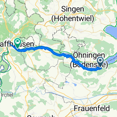
Overview
About this route
Long Tour, possible for mountainbike.
- -:--
- Duration
- 13.1 km
- Distance
- 252 m
- Ascent
- 237 m
- Descent
- ---
- Avg. speed
- ---
- Max. altitude
Route quality
Waytypes & surfaces along the route
Waytypes
Quiet road
7.3 km
(56 %)
Track
5.1 km
(39 %)
Surfaces
Paved
3.9 km
(30 %)
Unpaved
5.8 km
(44 %)
Asphalt
3.9 km
(30 %)
Pebblestone
3.7 km
(28 %)
Continue with Bikemap
Use, edit, or download this cycling route
You would like to ride Schloss Freudenfels - Bike I or customize it for your own trip? Here is what you can do with this Bikemap route:
Free features
- Save this route as favorite or in collections
- Copy & plan your own version of this route
- Sync your route with Garmin or Wahoo
Premium features
Free trial for 3 days, or one-time payment. More about Bikemap Premium.
- Navigate this route on iOS & Android
- Export a GPX / KML file of this route
- Create your custom printout (try it for free)
- Download this route for offline navigation
Discover more Premium features.
Get Bikemap PremiumFrom our community
Other popular routes starting in Eschenz
 Eschenz-Untersee-Rundfahrt
- Distance
- 75.1 km
- Ascent
- 196 m
- Descent
- 196 m
- Location
- Eschenz, Thurgau, Switzerland
 6 Mamern Langwiesen Schaffhausen
- Distance
- 24.8 km
- Ascent
- 165 m
- Descent
- 170 m
- Location
- Eschenz, Thurgau, Switzerland
 Eschenz-Stein
- Distance
- 2.5 km
- Ascent
- 0 m
- Descent
- 87 m
- Location
- Eschenz, Thurgau, Switzerland
 Schloss Freudenfels - Bike I
- Distance
- 13.1 km
- Ascent
- 252 m
- Descent
- 237 m
- Location
- Eschenz, Thurgau, Switzerland
 Mammern nach Frauenfeld
- Distance
- 14 km
- Ascent
- 235 m
- Descent
- 241 m
- Location
- Eschenz, Thurgau, Switzerland
 Rund um den Bodensee - Tag7 Mammern - Arbon
- Distance
- 63.2 km
- Ascent
- 84 m
- Descent
- 112 m
- Location
- Eschenz, Thurgau, Switzerland
 Tag 3: Stein am Rhein - Insel Reichenau - Konstanz
- Distance
- 52.6 km
- Ascent
- 248 m
- Descent
- 244 m
- Location
- Eschenz, Thurgau, Switzerland
 Schloss Freudenfels - Tour I
- Distance
- 2.3 km
- Ascent
- 95 m
- Descent
- 87 m
- Location
- Eschenz, Thurgau, Switzerland
Open it in the app