

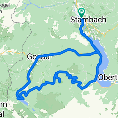
Bad Goisern nach Hallstatt
A cycling route starting in Bad Goisern am Hallstättersee, Upper Austria, Austria.
Overview
About this route
Mit den OEBB nach Bad Goisern, dann über Au zum Ostufer des Hallstädter Sees. Hier entlang des gut ausgebauten Radweges nach Obertraun. Hier kann man die Dachsteineishöhlen besuchen. Anschließend weiter nach Hallstatt. Mit der Fähre über den Hallstädter See zur OEBB Haltestelle Hallstatt (Achtung fährt nur bis ca. 18Uhr!)
- -:--
- Duration
- 22.4 km
- Distance
- 317 m
- Ascent
- 282 m
- Descent
- ---
- Avg. speed
- 608 m
- Max. altitude
Route quality
Waytypes & surfaces along the route
Waytypes
Track
6.1 km
(27 %)
Quiet road
4.3 km
(19 %)
Surfaces
Paved
15.5 km
(69 %)
Unpaved
6.1 km
(27 %)
Asphalt
15.4 km
(69 %)
Gravel
3.9 km
(18 %)
Continue with Bikemap
Use, edit, or download this cycling route
You would like to ride Bad Goisern nach Hallstatt or customize it for your own trip? Here is what you can do with this Bikemap route:
Free features
- Save this route as favorite or in collections
- Copy & plan your own version of this route
- Sync your route with Garmin or Wahoo
Premium features
Free trial for 3 days, or one-time payment. More about Bikemap Premium.
- Navigate this route on iOS & Android
- Export a GPX / KML file of this route
- Create your custom printout (try it for free)
- Download this route for offline navigation
Discover more Premium features.
Get Bikemap PremiumFrom our community
Other popular routes starting in Bad Goisern am Hallstättersee
 Hallstatt - RosAlm
- Distance
- 36.5 km
- Ascent
- 1,717 m
- Descent
- 1,726 m
- Location
- Bad Goisern am Hallstättersee, Upper Austria, Austria
 Hallstatt-Altausee-BadIschl-Hallstatt
- Distance
- 59.8 km
- Ascent
- 612 m
- Descent
- 612 m
- Location
- Bad Goisern am Hallstättersee, Upper Austria, Austria
 Jezera Solné komory: Hallstätter See a Vorderer Gosausee CLONED FROM ROUTE 759999
- Distance
- 46.9 km
- Ascent
- 1,563 m
- Descent
- 1,563 m
- Location
- Bad Goisern am Hallstättersee, Upper Austria, Austria
 Hallstatt - Ennsradweg - Prag - 2014
- Distance
- 668.7 km
- Ascent
- 1,491 m
- Descent
- 1,751 m
- Location
- Bad Goisern am Hallstättersee, Upper Austria, Austria
 In der Brandten, Bad Goisern am Hallstättersee nach Bahnstraße, Strobl am Wolfgangsee
- Distance
- 20.7 km
- Ascent
- 194 m
- Descent
- 139 m
- Location
- Bad Goisern am Hallstättersee, Upper Austria, Austria
 Salzkammer 1 den
- Distance
- 62.7 km
- Ascent
- 1,703 m
- Descent
- 1,703 m
- Location
- Bad Goisern am Hallstättersee, Upper Austria, Austria
 Hallstatt
- Distance
- 22.9 km
- Ascent
- 754 m
- Descent
- 754 m
- Location
- Bad Goisern am Hallstättersee, Upper Austria, Austria
 Okruh HSee
- Distance
- 22.9 km
- Ascent
- 294 m
- Descent
- 294 m
- Location
- Bad Goisern am Hallstättersee, Upper Austria, Austria
Open it in the app