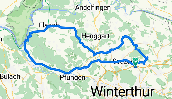
Flaachrunde
A cycling route starting in Oberwinterthur (Kreis 2) / Zinzikon, Canton of Zurich, Switzerland.
Overview
About this route
sher verkehrsarme strecken, ab teufen auf dem 60er radwanderweg,
Oft duch die Weinberge
- -:--
- Duration
- 43.6 km
- Distance
- 579 m
- Ascent
- 585 m
- Descent
- ---
- Avg. speed
- 525 m
- Avg. speed
Route quality
Waytypes & surfaces along the route
Waytypes
Road
22.1 km
(51 %)
Quiet road
8.7 km
(20 %)
Surfaces
Paved
41.2 km
(94 %)
Unpaved
0.4 km
(<1 %)
Asphalt
40.8 km
(94 %)
Paved (undefined)
0.4 km
(<1 %)
Continue with Bikemap
Use, edit, or download this cycling route
You would like to ride Flaachrunde or customize it for your own trip? Here is what you can do with this Bikemap route:
Free features
- Save this route as favorite or in collections
- Copy & plan your own version of this route
- Sync your route with Garmin or Wahoo
Premium features
Free trial for 3 days, or one-time payment. More about Bikemap Premium.
- Navigate this route on iOS & Android
- Export a GPX / KML file of this route
- Create your custom printout (try it for free)
- Download this route for offline navigation
Discover more Premium features.
Get Bikemap PremiumFrom our community
Other popular routes starting in Oberwinterthur (Kreis 2) / Zinzikon
- Wallrüti–Rheinau
- Distance
- 22.4 km
- Ascent
- 193 m
- Descent
- 282 m
- Location
- Oberwinterthur (Kreis 2) / Zinzikon, Canton of Zurich, Switzerland
- Rikon
- Distance
- 12.6 km
- Ascent
- 183 m
- Descent
- 134 m
- Location
- Oberwinterthur (Kreis 2) / Zinzikon, Canton of Zurich, Switzerland
- Wiesendangerstrasse 151, Stadel (Winterthur) nach Haldenrainstrasse 44, Stadel (Winterthur)
- Distance
- 8.1 km
- Ascent
- 110 m
- Descent
- 97 m
- Location
- Oberwinterthur (Kreis 2) / Zinzikon, Canton of Zurich, Switzerland
- Mein Jahr Dein Jahr
- Distance
- 205.1 km
- Ascent
- 1,799 m
- Descent
- 996 m
- Location
- Oberwinterthur (Kreis 2) / Zinzikon, Canton of Zurich, Switzerland
- laufrunde mörsburg
- Distance
- 11.8 km
- Ascent
- 113 m
- Descent
- 110 m
- Location
- Oberwinterthur (Kreis 2) / Zinzikon, Canton of Zurich, Switzerland
- Winterthur nord
- Distance
- 41.8 km
- Ascent
- 228 m
- Descent
- 242 m
- Location
- Oberwinterthur (Kreis 2) / Zinzikon, Canton of Zurich, Switzerland
- Moderate route in Winterthur
- Distance
- 18.3 km
- Ascent
- 735 m
- Descent
- 736 m
- Location
- Oberwinterthur (Kreis 2) / Zinzikon, Canton of Zurich, Switzerland
- halbe ume
- Distance
- 23.1 km
- Ascent
- 101 m
- Descent
- 101 m
- Location
- Oberwinterthur (Kreis 2) / Zinzikon, Canton of Zurich, Switzerland
Open it in the app