

Hof - Kornberg Rennrad
A cycling route starting in Döhlau, Bavaria, Germany.
Overview
About this route
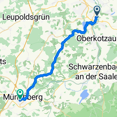
Start point: village exit Hof towards Oberkotzau.
Destination: summit of Kornberg.
Continuously paved, the last climb is steep, previously hilly.
Not long but demanding.
- -:--
- Duration
- 16.7 km
- Distance
- 473 m
- Ascent
- 140 m
- Descent
- ---
- Avg. speed
- 817 m
- Max. altitude

Route quality
Waytypes & surfaces along the route
Waytypes
Road
5.4 km
(32 %)
Quiet road
4.7 km
(28 %)
Surfaces
Paved
7.5 km
(45 %)
Unpaved
0.3 km
(2 %)
Asphalt
6.7 km
(40 %)
Paved (undefined)
0.8 km
(5 %)
Continue with Bikemap
Use, edit, or download this cycling route
You would like to ride Hof - Kornberg Rennrad or customize it for your own trip? Here is what you can do with this Bikemap route:
Free features
- Save this route as favorite or in collections
- Copy & plan your own version of this route
- Sync your route with Garmin or Wahoo
Premium features
Free trial for 3 days, or one-time payment. More about Bikemap Premium.
- Navigate this route on iOS & Android
- Export a GPX / KML file of this route
- Create your custom printout (try it for free)
- Download this route for offline navigation
Discover more Premium features.
Get Bikemap PremiumFrom our community
Other popular routes starting in Döhlau
 Bayreisches Vogtland
- Distance
- 33 km
- Ascent
- 297 m
- Descent
- 297 m
- Location
- Döhlau, Bavaria, Germany
 Zum Theresienstein u.Untreusee
- Distance
- 36.7 km
- Ascent
- 214 m
- Descent
- 215 m
- Location
- Döhlau, Bavaria, Germany
 Untreusee
- Distance
- 10.3 km
- Ascent
- 210 m
- Descent
- 209 m
- Location
- Döhlau, Bavaria, Germany
 Zeltbräu-Kemnitz-Stelzen-Tanna-Hirschberg
- Distance
- 76 km
- Ascent
- 609 m
- Descent
- 609 m
- Location
- Döhlau, Bavaria, Germany
 Hof - Kornberg Rennrad
- Distance
- 16.7 km
- Ascent
- 473 m
- Descent
- 140 m
- Location
- Döhlau, Bavaria, Germany
 Tri Sprint02
- Distance
- 21.2 km
- Ascent
- 175 m
- Descent
- 175 m
- Location
- Döhlau, Bavaria, Germany
 Hof-Münchberg
- Distance
- 19.5 km
- Ascent
- 247 m
- Descent
- 192 m
- Location
- Döhlau, Bavaria, Germany
 Hof-Prag
- Distance
- 240.5 km
- Ascent
- 1,361 m
- Descent
- 1,667 m
- Location
- Döhlau, Bavaria, Germany
Open it in the app