

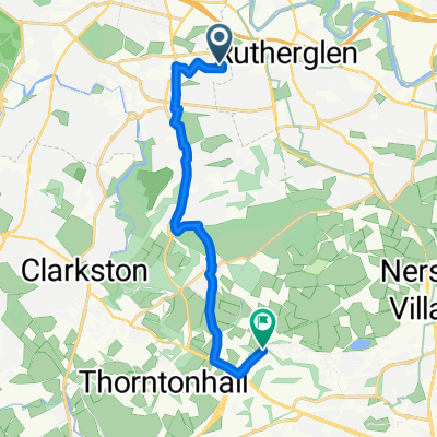
Glasgow Hospitals: NVH to GRI
A cycling route starting in Rutherglen, Scotland, United Kingdom.
Overview
About this route
A route from New Victoria Hospital, Battlefield to Glasgow Royal Infirmary.
Mostly quiet roads and cycle/bus/taxi routes. Busier main road sections have been avoided largely or can be avoided with a bit of thinking. The final ascent up Wishart Street to the GRI is quite steep! Be warned!- -:--
- Duration
- 5.6 km
- Distance
- 60 m
- Ascent
- 46 m
- Descent
- ---
- Avg. speed
- ---
- Max. altitude

Route quality
Waytypes & surfaces along the route
Waytypes
Quiet road
1.9 km
(34 %)
Road
1.9 km
(33 %)
Surfaces
Paved
4.4 km
(78 %)
Asphalt
4.4 km
(78 %)
Undefined
1.2 km
(22 %)
Continue with Bikemap
Use, edit, or download this cycling route
You would like to ride Glasgow Hospitals: NVH to GRI or customize it for your own trip? Here is what you can do with this Bikemap route:
Free features
- Save this route as favorite or in collections
- Copy & plan your own version of this route
- Sync your route with Garmin or Wahoo
Premium features
Free trial for 3 days, or one-time payment. More about Bikemap Premium.
- Navigate this route on iOS & Android
- Export a GPX / KML file of this route
- Create your custom printout (try it for free)
- Download this route for offline navigation
Discover more Premium features.
Get Bikemap PremiumFrom our community
Other popular routes starting in Rutherglen
 Zrelaksowana trasa w Glasgow
- Distance
- 13.1 km
- Ascent
- 101 m
- Descent
- 105 m
- Location
- Rutherglen, Scotland, United Kingdom
 Glenmore Avenue, Glasgow to Glen Road, Glasgow
- Distance
- 9.9 km
- Ascent
- 177 m
- Descent
- 54 m
- Location
- Rutherglen, Scotland, United Kingdom
 Route 1
- Distance
- 61.4 km
- Ascent
- 417 m
- Descent
- 420 m
- Location
- Rutherglen, Scotland, United Kingdom
 Glasgow Hospitals: NVH to GRI
- Distance
- 5.6 km
- Ascent
- 60 m
- Descent
- 46 m
- Location
- Rutherglen, Scotland, United Kingdom
 Natalia Glasgow
- Distance
- 11.5 km
- Ascent
- 31 m
- Descent
- 43 m
- Location
- Rutherglen, Scotland, United Kingdom
 548 Carntyne Road, Glasgow do 59 Merchiston Street, Glasgow
- Distance
- 100.4 km
- Ascent
- 699 m
- Descent
- 695 m
- Location
- Rutherglen, Scotland, United Kingdom
 Td4 - Blue Route updated ref Robroyston diversion
- Distance
- 61.5 km
- Ascent
- 477 m
- Descent
- 479 m
- Location
- Rutherglen, Scotland, United Kingdom
 Ewan's Run
- Distance
- 0.2 km
- Ascent
- 0 m
- Descent
- 4 m
- Location
- Rutherglen, Scotland, United Kingdom
Open it in the app