

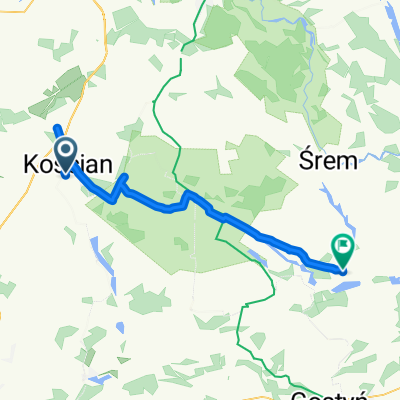
dolsk
A cycling route starting in Kościan, Greater Poland Voivodeship, Poland.
Overview
About this route
i kesze
- -:--
- Duration
- 44.1 km
- Distance
- 134 m
- Ascent
- 93 m
- Descent
- ---
- Avg. speed
- ---
- Max. altitude

Route quality
Waytypes & surfaces along the route
Waytypes
Road
20.4 km
(46 %)
Track
9 km
(20 %)
Surfaces
Paved
23.4 km
(53 %)
Unpaved
3.4 km
(8 %)
Asphalt
23.4 km
(53 %)
Gravel
2.5 km
(6 %)
Route highlights
Points of interest along the route
Drinking water after 0.5 km
Mostek - Kesz to magnetyk na kordach (+/- 3 m). Skrzynka umieszczona dosyć wysoko. Należy uważać na ciągle przechodzących spacerowiczów i śmigających rowerzystów :)
Point of interest after 4.4 km
traktor z magnetykiem dla leworęcznych
Drinking water after 7.9 km
Stary pień
Drinking water after 7.9 km
W starym drzewie w pobliżu krzyża
Drinking water after 12.6 km
Skrzynka to pojemnik PET ukryty nisko przy pniu drzewa w nieco większym maskowaniu. Aby się do niego dostać trzeba uchylić w bok.
Point of interest after 14.1 km
Na środkowej podpórce barierki mostku - mikro magnetyk
Point of interest after 23.7 km
Metalowy krucyfiks - Skrzynka to mały pojemnik ukryty w większym maskowaniu otwieranym do góry.
Point of interest after 24.9 km
Skrzynka to mały pojemnik zamykany na klipsy ukryty na Starym dzewie tam gdzie życie się odrodzilo
Point of interest after 27.7 km
Wieża widokowa na trasie rowerowej. Skrzynka to mały pojemnik (120x90x50 mm) na pierwszym podeście wieży pod poręczą. Z prawej strony.
Point of interest after 30 km
Skrzynka to pojemnik wielkości PET ukryty w narożniku nisko przy ziemi. betonowy płot
Drinking water after 41.1 km
Należy szukać pieńka i kopać zaraz przy nim. Zaraz za podestem pseudo
Continue with Bikemap
Use, edit, or download this cycling route
You would like to ride dolsk or customize it for your own trip? Here is what you can do with this Bikemap route:
Free features
- Save this route as favorite or in collections
- Copy & plan your own version of this route
- Sync your route with Garmin or Wahoo
Premium features
Free trial for 3 days, or one-time payment. More about Bikemap Premium.
- Navigate this route on iOS & Android
- Export a GPX / KML file of this route
- Create your custom printout (try it for free)
- Download this route for offline navigation
Discover more Premium features.
Get Bikemap PremiumFrom our community
Other popular routes starting in Kościan
 Klemensa Kruszewskiego 13, Kościan to Klemensa Kruszewskiego 13, Kościan
- Distance
- 18.9 km
- Ascent
- 116 m
- Descent
- 115 m
- Location
- Kościan, Greater Poland Voivodeship, Poland
 Północny zachód od Kościana
- Distance
- 30.2 km
- Ascent
- 53 m
- Descent
- 51 m
- Location
- Kościan, Greater Poland Voivodeship, Poland
 dolsk
dolsk- Distance
- 44.1 km
- Ascent
- 134 m
- Descent
- 93 m
- Location
- Kościan, Greater Poland Voivodeship, Poland
 hfvkg
hfvkg- Distance
- 57.8 km
- Ascent
- 102 m
- Descent
- 101 m
- Location
- Kościan, Greater Poland Voivodeship, Poland
 Kościańska 10, Stary Lubosz do Kościańska 10, Stary Lubosz
- Distance
- 16.8 km
- Ascent
- 91 m
- Descent
- 90 m
- Location
- Kościan, Greater Poland Voivodeship, Poland
 pętla 62 km
- Distance
- 62 km
- Ascent
- 144 m
- Descent
- 141 m
- Location
- Kościan, Greater Poland Voivodeship, Poland
 Na południe od Kościana
- Distance
- 29.8 km
- Ascent
- 65 m
- Descent
- 66 m
- Location
- Kościan, Greater Poland Voivodeship, Poland
 Dookoła jezior: Wonieść i Jezierzyckiego
- Distance
- 41.8 km
- Ascent
- 101 m
- Descent
- 100 m
- Location
- Kościan, Greater Poland Voivodeship, Poland
Open it in the app