

chancy
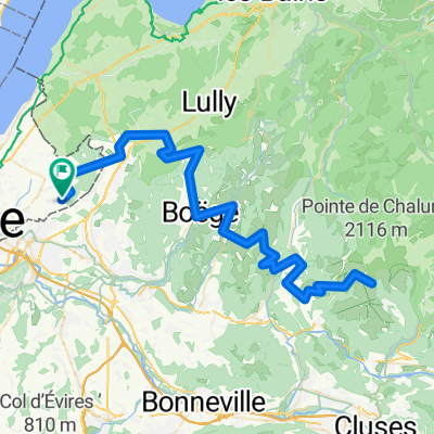
A cycling route starting in Ville-la-Grand, Auvergne-Rhône-Alpes, France.
Overview
About this route
ville la grand,chancy, la praille
(cloned from route 3386796)- -:--
- Duration
- 53.2 km
- Distance
- 341 m
- Ascent
- 394 m
- Descent
- ---
- Avg. speed
- ---
- Max. altitude
Route quality
Waytypes & surfaces along the route
Waytypes
Road
23.8 km
(45 %)
Quiet road
10.2 km
(19 %)
Surfaces
Paved
49 km
(92 %)
Unpaved
0.3 km
(<1 %)
Asphalt
48.3 km
(91 %)
Paved (undefined)
0.5 km
(<1 %)
Continue with Bikemap
Use, edit, or download this cycling route
You would like to ride chancy or customize it for your own trip? Here is what you can do with this Bikemap route:
Free features
- Save this route as favorite or in collections
- Copy & plan your own version of this route
- Sync your route with Garmin or Wahoo
Premium features
Free trial for 3 days, or one-time payment. More about Bikemap Premium.
- Navigate this route on iOS & Android
- Export a GPX / KML file of this route
- Create your custom printout (try it for free)
- Download this route for offline navigation
Discover more Premium features.
Get Bikemap PremiumFrom our community
Other popular routes starting in Ville-la-Grand
 F/1 Annemasse_Crest-Voland
- Distance
- 74.4 km
- Ascent
- 1,614 m
- Descent
- 809 m
- Location
- Ville-la-Grand, Auvergne-Rhône-Alpes, France
 chancy
- Distance
- 53.2 km
- Ascent
- 341 m
- Descent
- 394 m
- Location
- Ville-la-Grand, Auvergne-Rhône-Alpes, France
 Grand bornand
- Distance
- 124.8 km
- Ascent
- 2,179 m
- Descent
- 2,156 m
- Location
- Ville-la-Grand, Auvergne-Rhône-Alpes, France
 col de cou par Fessy Saxel
- Distance
- 63.3 km
- Ascent
- 891 m
- Descent
- 890 m
- Location
- Ville-la-Grand, Auvergne-Rhône-Alpes, France
 Mieussy
- Distance
- 83.7 km
- Ascent
- 1,356 m
- Descent
- 1,367 m
- Location
- Ville-la-Grand, Auvergne-Rhône-Alpes, France
 STB_Barca_act_006_0810_Annemasse_bei_Genf (France) - Chambery
- Distance
- 98.5 km
- Ascent
- 728 m
- Descent
- 938 m
- Location
- Ville-la-Grand, Auvergne-Rhône-Alpes, France
 *XX-M. Ville-la-Grand - Plateau des Saix (Km 152)
- Distance
- 152 km
- Ascent
- 4,782 m
- Descent
- 3,610 m
- Location
- Ville-la-Grand, Auvergne-Rhône-Alpes, France
 Presinge, Plaine-Joux, Ramaz, retour
- Distance
- 117.9 km
- Ascent
- 2,479 m
- Descent
- 2,482 m
- Location
- Ville-la-Grand, Auvergne-Rhône-Alpes, France
Open it in the app