

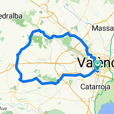
Sedaví- Parador del Saler
A cycling route starting in Sedaví, Valencia, Spain.
Overview
About this route
Camino de recreo que trascurre entre caminos poco transitados, que da la oportunidad de dar un paseo por la zona del saler y el parque natural, hay muchos tramos para poder ir con la bici de carretera, epro el tramo de cortafuegos ni lo intenteis, solo montaña, hay mucha peidra suelta y gravilla, si ha llovido cuidado con los barrizales, se montan unos muy gordos en mitad del camino y aun no sindo profundos, es necesario ir con cuidado. Los caminos de conexión por castellar no presenta ningun tipo de problema siempre se enceuntra abierto, pero el camino de interconexión de vuelta hacia alfafar, en épocas de caza o si veis que estan los campos inundados, no se puede pasar, en caza por el epligro que supone, y si esta inundado porque hay un trozo que el camino es de arena, y desaparece parcialmente, vmaso no hay camino o el paso es imposible por el mismo. En estas épocas se coge el camino de el saler alfafar, carretera asfatada, y sin ningun tipo de problema para su paso, espero que os sirva de ayuda. este recorrido es totalemtne llano a excepción de dos puentes pero vamso no presentan ninguna dificultad.
- -:--
- Duration
- 38.3 km
- Distance
- 29 m
- Ascent
- 39 m
- Descent
- ---
- Avg. speed
- 12 m
- Max. altitude

Route quality
Waytypes & surfaces along the route
Waytypes
Track
14.3 km
(37 %)
Quiet road
11.5 km
(30 %)
Surfaces
Paved
20.1 km
(52 %)
Unpaved
8.3 km
(22 %)
Asphalt
10.6 km
(28 %)
Concrete
7.1 km
(19 %)
Route highlights
Points of interest along the route
Point of interest after 28.2 km
Este tramo se enceuntra iinundado cuando esta creciendo el arroz, el paso por aquí se hace casi imposible o imposible en bicicleta.
Point of interest after 28.6 km
Trozo inundado
Point of interest after 32.1 km
aquí se peude coger el camino alternativo por la carretera del Saler caundo el camino esta inundado o esta cerrado por caza.
Continue with Bikemap
Use, edit, or download this cycling route
You would like to ride Sedaví- Parador del Saler or customize it for your own trip? Here is what you can do with this Bikemap route:
Free features
- Save this route as favorite or in collections
- Copy & plan your own version of this route
- Sync your route with Garmin or Wahoo
Premium features
Free trial for 3 days, or one-time payment. More about Bikemap Premium.
- Navigate this route on iOS & Android
- Export a GPX / KML file of this route
- Create your custom printout (try it for free)
- Download this route for offline navigation
Discover more Premium features.
Get Bikemap PremiumFrom our community
Other popular routes starting in Sedaví
 San Marcelino (Valencia)-Picanya-Torrent-Picassent-Llombai (Besori) y vuelta por Picassent
- Distance
- 59.1 km
- Ascent
- 312 m
- Descent
- 316 m
- Location
- Sedaví, Valencia, Spain
 VALENCIA- DESIERTO LAS PALMAS -BENICASIMJ
- Distance
- 135 km
- Ascent
- 964 m
- Descent
- 967 m
- Location
- Sedaví, Valencia, Spain
 valencia-gandia
- Distance
- 131.8 km
- Ascent
- 987 m
- Descent
- 995 m
- Location
- Sedaví, Valencia, Spain
 Bº SAN MARCELINO-ADEMUZ
- Distance
- 137.7 km
- Ascent
- 1,472 m
- Descent
- 776 m
- Location
- Sedaví, Valencia, Spain
 Valencia-Villamarchante-Godelleta-Torrente-Valencia
- Distance
- 86.2 km
- Ascent
- 360 m
- Descent
- 362 m
- Location
- Sedaví, Valencia, Spain
 La Vallesa - Dragon Khan
- Distance
- 50.2 km
- Ascent
- 221 m
- Descent
- 221 m
- Location
- Sedaví, Valencia, Spain
 RUTA FUENTE REAL-CORTA
- Distance
- 88.8 km
- Ascent
- 986 m
- Descent
- 989 m
- Location
- Sedaví, Valencia, Spain
 Rondrit Valencia 12 km.
- Distance
- 11.9 km
- Ascent
- 91 m
- Descent
- 92 m
- Location
- Sedaví, Valencia, Spain
Open it in the app