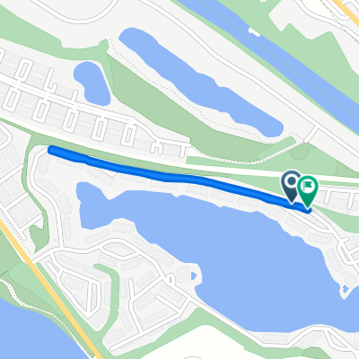
WF to WF for Feb YAY (west to east)
A cycling route starting in Upper Arlington, Ohio, United States of America.
Overview
About this route
The proposed February route for the Whole Foods Meetup ride, going west to east.
- -:--
- Duration
- 20.7 km
- Distance
- 87 m
- Ascent
- 83 m
- Descent
- ---
- Avg. speed
- ---
- Max. altitude
Route quality
Waytypes & surfaces along the route
Waytypes
Quiet road
7.6 km
(37 %)
Cycleway
4.6 km
(22 %)
Surfaces
Paved
17.8 km
(86 %)
Asphalt
11.6 km
(56 %)
Paved (undefined)
6.1 km
(29 %)
Continue with Bikemap
Use, edit, or download this cycling route
You would like to ride WF to WF for Feb YAY (west to east) or customize it for your own trip? Here is what you can do with this Bikemap route:
Free features
- Save this route as favorite or in collections
- Copy & plan your own version of this route
- Sync your route with Garmin or Wahoo
Premium features
Free trial for 3 days, or one-time payment. More about Bikemap Premium.
- Navigate this route on iOS & Android
- Export a GPX / KML file of this route
- Create your custom printout (try it for free)
- Download this route for offline navigation
Discover more Premium features.
Get Bikemap PremiumFrom our community
Other popular routes starting in Upper Arlington
- 75 W Lakeview Ave, Columbus to 81 W Lakeview Ave, Columbus
- Distance
- 24.1 km
- Ascent
- 734 m
- Descent
- 734 m
- Location
- Upper Arlington, Ohio, United States of America
- Whole Foods Lane to Whole Foods Easton
- Distance
- 20.6 km
- Ascent
- 82 m
- Descent
- 75 m
- Location
- Upper Arlington, Ohio, United States of America
- Como Park to and through Campus
- Distance
- 10.5 km
- Ascent
- 34 m
- Descent
- 34 m
- Location
- Upper Arlington, Ohio, United States of America
- East California Avenue 60-62, Columbus to East College Street 203, Granville
- Distance
- 71.5 km
- Ascent
- 361 m
- Descent
- 301 m
- Location
- Upper Arlington, Ohio, United States of America
- loop #1
- Distance
- 6.7 km
- Ascent
- 11 m
- Descent
- 13 m
- Location
- Upper Arlington, Ohio, United States of America
- Missing Section
- Distance
- 44.8 km
- Ascent
- 89 m
- Descent
- 64 m
- Location
- Upper Arlington, Ohio, United States of America
- 1770 Drayton Park Ct, Columbus to 1758 Drayton Park Ct, Columbus
- Distance
- 17.1 km
- Ascent
- 500 m
- Descent
- 500 m
- Location
- Upper Arlington, Ohio, United States of America
- Cracking ride in Columbus
- Distance
- 40.2 km
- Ascent
- 242 m
- Descent
- 240 m
- Location
- Upper Arlington, Ohio, United States of America
Open it in the app