
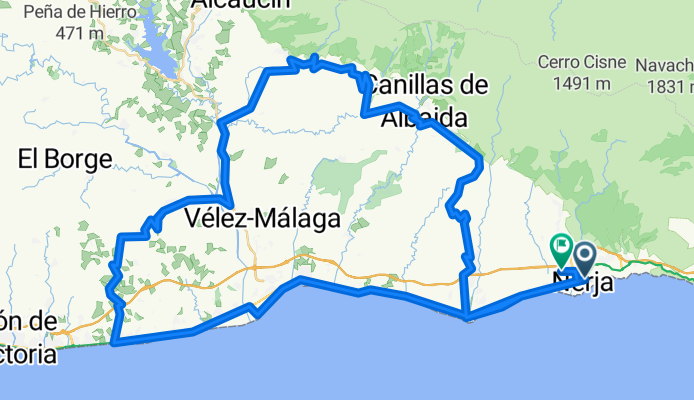
Nerja - Torrox - Sedella - Iznate - Benjarafe
A cycling route starting in Nerja, Andalusia, Spain.
Overview
About this route
...
- -:--
- Duration
- 114.7 km
- Distance
- 1,529 m
- Ascent
- 1,528 m
- Descent
- ---
- Avg. speed
- ---
- Max. altitude

Route quality
Waytypes & surfaces along the route
Waytypes
Road
40.1 km
(35 %)
Quiet road
25 km
(22 %)
Surfaces
Paved
53.5 km
(47 %)
Unpaved
15.9 km
(14 %)
Asphalt
43.6 km
(38 %)
Paved (undefined)
8.6 km
(7 %)
Continue with Bikemap
Use, edit, or download this cycling route
You would like to ride Nerja - Torrox - Sedella - Iznate - Benjarafe or customize it for your own trip? Here is what you can do with this Bikemap route:
Free features
- Save this route as favorite or in collections
- Copy & plan your own version of this route
- Split it into stages to create a multi-day tour
- Sync your route with Garmin or Wahoo
Premium features
Free trial for 3 days, or one-time payment. More about Bikemap Premium.
- Navigate this route on iOS & Android
- Export a GPX / KML file of this route
- Create your custom printout (try it for free)
- Download this route for offline navigation
Discover more Premium features.
Get Bikemap PremiumFrom our community
Other popular routes starting in Nerja
 Nerja-La cabra-La Zubia
- Distance
- 94.1 km
- Ascent
- 1,716 m
- Descent
- 1,005 m
- Location
- Nerja, Andalusia, Spain
 Calle Bouganvilla 91, Nerja to Calle Bouganvilla 91, Nerja
- Distance
- 36.2 km
- Ascent
- 328 m
- Descent
- 747 m
- Location
- Nerja, Andalusia, Spain
 Nerja to Heradura return
- Distance
- 47.1 km
- Ascent
- 796 m
- Descent
- 803 m
- Location
- Nerja, Andalusia, Spain
 Primera ruta de Esther
- Distance
- 14.3 km
- Ascent
- 316 m
- Descent
- 324 m
- Location
- Nerja, Andalusia, Spain
 Benamocarra loop
- Distance
- 53.7 km
- Ascent
- 316 m
- Descent
- 350 m
- Location
- Nerja, Andalusia, Spain
 La Herradura via cg
- Distance
- 46.7 km
- Ascent
- 798 m
- Descent
- 801 m
- Location
- Nerja, Andalusia, Spain
 nerja-Competa-Canillas-Velez-TorroxCosta-Nerja
- Distance
- 94 km
- Ascent
- 2,262 m
- Descent
- 2,267 m
- Location
- Nerja, Andalusia, Spain
 La Herradura via Cerro Gordo
- Distance
- 46.8 km
- Ascent
- 871 m
- Descent
- 871 m
- Location
- Nerja, Andalusia, Spain
Open it in the app