

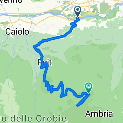
Sentiero Rusca da Albosaggia a Chiesa in Valmalenco
A cycling route starting in Torchione-Moia, Lombardy, Italy.
Overview
About this route
Bellissimo e panoramico itinerario che porta a Chiesa in Valmalenco e proseguibile, con più difficoltà, fino al Passo del Muretto sul confine Svizzero. Il primo tratto con la visita della città di Sondrio, sale verso la Via dei Terrazzamenti con il panorama sulla Valtellina ed i suoi vigneti. Poi immersi nella valle si sale dolcemente presso il torrente Mallero fino ad arrivare alla meta.
- -:--
- Duration
- 18.2 km
- Distance
- 736 m
- Ascent
- 46 m
- Descent
- ---
- Avg. speed
- ---
- Max. altitude
Continue with Bikemap
Use, edit, or download this cycling route
You would like to ride Sentiero Rusca da Albosaggia a Chiesa in Valmalenco or customize it for your own trip? Here is what you can do with this Bikemap route:
Free features
- Save this route as favorite or in collections
- Copy & plan your own version of this route
- Sync your route with Garmin or Wahoo
Premium features
Free trial for 3 days, or one-time payment. More about Bikemap Premium.
- Navigate this route on iOS & Android
- Export a GPX / KML file of this route
- Create your custom printout (try it for free)
- Download this route for offline navigation
Discover more Premium features.
Get Bikemap PremiumFrom our community
Other popular routes starting in Torchione-Moia
 Sondrio - Colico 12.9.2018
- Distance
- 45 km
- Ascent
- 112 m
- Descent
- 200 m
- Location
- Torchione-Moia, Lombardy, Italy
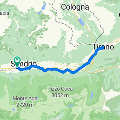
 Escursione Sondrio-Tirano
- Distance
- 30.7 km
- Ascent
- 410 m
- Descent
- 266 m
- Location
- Torchione-Moia, Lombardy, Italy
 Sentiero Rusca da Albosaggia a Chiesa in Valmalenco
- Distance
- 18.2 km
- Ascent
- 736 m
- Descent
- 46 m
- Location
- Torchione-Moia, Lombardy, Italy
 sondrio - lanzada
- Distance
- 20.4 km
- Ascent
- 879 m
- Descent
- 193 m
- Location
- Torchione-Moia, Lombardy, Italy
 Alpe Campelli
- Distance
- 11.4 km
- Ascent
- 1,071 m
- Descent
- 17 m
- Location
- Torchione-Moia, Lombardy, Italy
 Von Sondrio bis Piateda
- Distance
- 19.8 km
- Ascent
- 2,353 m
- Descent
- 520 m
- Location
- Torchione-Moia, Lombardy, Italy
 Decouville delle Orobie Valtellinesi - da Albosaggia Porto
- Distance
- 41.4 km
- Ascent
- 911 m
- Descent
- 904 m
- Location
- Torchione-Moia, Lombardy, Italy
 Sondrio - Tirano ebike
- Distance
- 64.5 km
- Ascent
- 635 m
- Descent
- 635 m
- Location
- Torchione-Moia, Lombardy, Italy
Open it in the app