

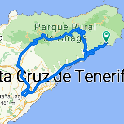
Anaga- Nivel Medio
A cycling route starting in Santa Cruz de Tenerife, Canary Islands, Spain.
Overview
About this route
Anaga - Intermediate level
- -:--
- Duration
- 53.1 km
- Distance
- 1,142 m
- Ascent
- 1,142 m
- Descent
- ---
- Avg. speed
- ---
- Max. altitude

Route quality
Waytypes & surfaces along the route
Waytypes
Pedestrian area
6.4 km
(12 %)
Quiet road
5.8 km
(11 %)
Surfaces
Paved
30.8 km
(58 %)
Asphalt
30.8 km
(58 %)
Undefined
22.3 km
(42 %)
Continue with Bikemap
Use, edit, or download this cycling route
You would like to ride Anaga- Nivel Medio or customize it for your own trip? Here is what you can do with this Bikemap route:
Free features
- Save this route as favorite or in collections
- Copy & plan your own version of this route
- Sync your route with Garmin or Wahoo
Premium features
Free trial for 3 days, or one-time payment. More about Bikemap Premium.
- Navigate this route on iOS & Android
- Export a GPX / KML file of this route
- Create your custom printout (try it for free)
- Download this route for offline navigation
Discover more Premium features.
Get Bikemap PremiumFrom our community
Other popular routes starting in Santa Cruz de Tenerife
 Santa Cruz nach iqueste
- Distance
- 15.1 km
- Ascent
- 546 m
- Descent
- 505 m
- Location
- Santa Cruz de Tenerife, Canary Islands, Spain
 Agana2
- Distance
- 71.3 km
- Ascent
- 1,451 m
- Descent
- 1,471 m
- Location
- Santa Cruz de Tenerife, Canary Islands, Spain
 Санта Круз - Север
- Distance
- 49.9 km
- Ascent
- 1,134 m
- Descent
- 1,138 m
- Location
- Santa Cruz de Tenerife, Canary Islands, Spain
 Santa Cruz - Santa Cruz (EZF)
- Distance
- 26.4 km
- Ascent
- 889 m
- Descent
- 567 m
- Location
- Santa Cruz de Tenerife, Canary Islands, Spain
 Santa Cruz - Bailadero - Pico del Inglés - Las Mercedes - La Cuesta - Santa Cruz
- Distance
- 51.3 km
- Ascent
- 1,158 m
- Descent
- 1,160 m
- Location
- Santa Cruz de Tenerife, Canary Islands, Spain
 Teneriffatour6
- Distance
- 158.1 km
- Ascent
- 1,856 m
- Descent
- 1,837 m
- Location
- Santa Cruz de Tenerife, Canary Islands, Spain
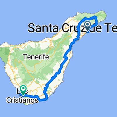
 Santa Cruz de Tenerife - Los Cristianos
- Distance
- 168.1 km
- Ascent
- 3,646 m
- Descent
- 3,674 m
- Location
- Santa Cruz de Tenerife, Canary Islands, Spain
 Sc-Granadilla-Los Cristianos-Chio-Izaña-La Laguna.Sc
- Distance
- 232.9 km
- Ascent
- 3,565 m
- Descent
- 3,565 m
- Location
- Santa Cruz de Tenerife, Canary Islands, Spain
Open it in the app