

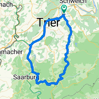
2002_Kyll - Our - Sauer - Mosel (Trier - Gerolstein - Kronenburg - Losheim - Vianden - Trier)
A cycling route starting in Kenn, Rhineland-Palatinate, Germany.
Overview
About this route
bei Trier-Ehrang die Kyll hinauf - über Gerolstein nach Frauenkron zur Kyllquelle - bei Losheimer Graben zur Ourquelle - an der Our entlang über Vianden bis zur Mündung in die Sauer bei Wallendorf - über Echternach und Wasserbillig an die Mosel und weiter nach Trier
(cloned from route 254789)
- -:--
- Duration
- 294 km
- Distance
- 1,027 m
- Ascent
- 1,027 m
- Descent
- ---
- Avg. speed
- ---
- Avg. speed

Route quality
Waytypes & surfaces along the route
Waytypes
Busy road
140.7 km
(48 %)
Quiet road
46.7 km
(16 %)
Surfaces
Paved
207.9 km
(71 %)
Unpaved
22.2 km
(8 %)
Asphalt
193.6 km
(66 %)
Ground
14.3 km
(5 %)
Continue with Bikemap
Use, edit, or download this cycling route
You would like to ride 2002_Kyll - Our - Sauer - Mosel (Trier - Gerolstein - Kronenburg - Losheim - Vianden - Trier) or customize it for your own trip? Here is what you can do with this Bikemap route:
Free features
- Save this route as favorite or in collections
- Copy & plan your own version of this route
- Split it into stages to create a multi-day tour
- Sync your route with Garmin or Wahoo
Premium features
Free trial for 3 days, or one-time payment. More about Bikemap Premium.
- Navigate this route on iOS & Android
- Export a GPX / KML file of this route
- Create your custom printout (try it for free)
- Download this route for offline navigation
Discover more Premium features.
Get Bikemap PremiumFrom our community
Other popular routes starting in Kenn
 De Zum Ehranger Wald 2A, Trèves à Zum Ehranger Wald 2B, Trèves
- Distance
- 39.2 km
- Ascent
- 1,044 m
- Descent
- 1,054 m
- Location
- Kenn, Rhineland-Palatinate, Germany
 Ausfahrt durch Trier
- Distance
- 26.2 km
- Ascent
- 219 m
- Descent
- 215 m
- Location
- Kenn, Rhineland-Palatinate, Germany
 Lange Ausfahrt durch Trier
- Distance
- 70.2 km
- Ascent
- 503 m
- Descent
- 503 m
- Location
- Kenn, Rhineland-Palatinate, Germany
 Ruwer-Radweg
- Distance
- 50.9 km
- Ascent
- 537 m
- Descent
- 194 m
- Location
- Kenn, Rhineland-Palatinate, Germany
 Moselradweg Trier-Koblenz
- Distance
- 16 km
- Ascent
- 78 m
- Descent
- 79 m
- Location
- Kenn, Rhineland-Palatinate, Germany
 Unbenannte Route
- Distance
- 240.4 km
- Ascent
- 3,177 m
- Descent
- 3,175 m
- Location
- Kenn, Rhineland-Palatinate, Germany
 Nach Mehring
- Distance
- 25.6 km
- Ascent
- 532 m
- Descent
- 531 m
- Location
- Kenn, Rhineland-Palatinate, Germany
 Weinberg u. Rehe Mertesdorf-Kasel
- Distance
- 13.4 km
- Ascent
- 262 m
- Descent
- 261 m
- Location
- Kenn, Rhineland-Palatinate, Germany
Open it in the app