

RTF Rhein-Neckar-Odenwald
A cycling route starting in Schwetzingen, Baden-Wurttemberg, Germany.
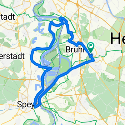
Overview
About this route
Radsportbezirk RNO Route
- -:--
- Duration
- 79.7 km
- Distance
- 298 m
- Ascent
- 299 m
- Descent
- ---
- Avg. speed
- ---
- Max. altitude

Route quality
Waytypes & surfaces along the route
Waytypes
Quiet road
21.3 km
(27 %)
Road
16.2 km
(20 %)
Surfaces
Paved
73.2 km
(92 %)
Unpaved
0.2 km
(<1 %)
Asphalt
69.4 km
(87 %)
Paved (undefined)
2.3 km
(3 %)
Continue with Bikemap
Use, edit, or download this cycling route
You would like to ride RTF Rhein-Neckar-Odenwald or customize it for your own trip? Here is what you can do with this Bikemap route:
Free features
- Save this route as favorite or in collections
- Copy & plan your own version of this route
- Sync your route with Garmin or Wahoo
Premium features
Free trial for 3 days, or one-time payment. More about Bikemap Premium.
- Navigate this route on iOS & Android
- Export a GPX / KML file of this route
- Create your custom printout (try it for free)
- Download this route for offline navigation
Discover more Premium features.
Get Bikemap PremiumFrom our community
Other popular routes starting in Schwetzingen
 große Feierabendrunde
- Distance
- 48.4 km
- Ascent
- 54 m
- Descent
- 51 m
- Location
- Schwetzingen, Baden-Wurttemberg, Germany
 kleine Altriprunde
- Distance
- 48.3 km
- Ascent
- 63 m
- Descent
- 68 m
- Location
- Schwetzingen, Baden-Wurttemberg, Germany
 L 543, Schwetzingen nach Geheimrat-Schott-Straße, Leimen
- Distance
- 16.3 km
- Ascent
- 57 m
- Descent
- 41 m
- Location
- Schwetzingen, Baden-Wurttemberg, Germany
 Short bike tour through Schwetzingen
- Distance
- 0 km
- Ascent
- 0 m
- Descent
- 0 m
- Location
- Schwetzingen, Baden-Wurttemberg, Germany
 RTF Rhein-Neckar-Odenwald
- Distance
- 79.7 km
- Ascent
- 298 m
- Descent
- 299 m
- Location
- Schwetzingen, Baden-Wurttemberg, Germany
 Durchs Feld
- Distance
- 23.6 km
- Ascent
- 64 m
- Descent
- 64 m
- Location
- Schwetzingen, Baden-Wurttemberg, Germany
 21km
21km- Distance
- 20.8 km
- Ascent
- 31 m
- Descent
- 31 m
- Location
- Schwetzingen, Baden-Wurttemberg, Germany
 RTF Odenwaldtour
- Distance
- 80.7 km
- Ascent
- 905 m
- Descent
- 904 m
- Location
- Schwetzingen, Baden-Wurttemberg, Germany
Open it in the app