

Cyclesummit 2016 Tour 2
A cycling route starting in Bullas, Murcia, Spain.
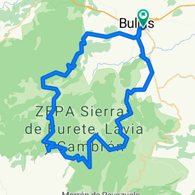
Overview
About this route
We will start at the Bullas wine museum, where we will learn about the important and distinctive features of wines from Bullas. After going through Bullas old town, we will follow the Northwestern Greenway to Cehegín. By stopping at Begastri, we will discover the secrets of this Iberian- Visigothic site, which is really unique within the peninsular southeast. We will then follow the Greenway up to the village of Cehegín. The route will finish at Las Fuentes del Marqués (or at the Vera Cruz Sanctuary).
- -:--
- Duration
- 26.9 km
- Distance
- 230 m
- Ascent
- 227 m
- Descent
- ---
- Avg. speed
- ---
- Max. altitude
Route quality
Waytypes & surfaces along the route
Waytypes
Cycleway
13.6 km
(51 %)
Quiet road
12.7 km
(47 %)
Surfaces
Paved
12.8 km
(47 %)
Unpaved
12.1 km
(45 %)
Asphalt
11 km
(41 %)
Ground
7.4 km
(28 %)
Continue with Bikemap
Use, edit, or download this cycling route
You would like to ride Cyclesummit 2016 Tour 2 or customize it for your own trip? Here is what you can do with this Bikemap route:
Free features
- Save this route as favorite or in collections
- Copy & plan your own version of this route
- Sync your route with Garmin or Wahoo
Premium features
Free trial for 3 days, or one-time payment. More about Bikemap Premium.
- Navigate this route on iOS & Android
- Export a GPX / KML file of this route
- Create your custom printout (try it for free)
- Download this route for offline navigation
Discover more Premium features.
Get Bikemap PremiumFrom our community
Other popular routes starting in Bullas
 selva2
- Distance
- 26.5 km
- Ascent
- 307 m
- Descent
- 559 m
- Location
- Bullas, Murcia, Spain
 Cyclesummit 2016 Tour 2
- Distance
- 26.9 km
- Ascent
- 230 m
- Descent
- 227 m
- Location
- Bullas, Murcia, Spain
 Burete-Ceperos-Bullas
- Distance
- 45.3 km
- Ascent
- 634 m
- Descent
- 634 m
- Location
- Bullas, Murcia, Spain
 Sierra Espuña - La Selva
- Distance
- 113 km
- Ascent
- 1,545 m
- Descent
- 1,545 m
- Location
- Bullas, Murcia, Spain
 Bullas - Venta del Pino - Hoya Lóbrega - Aceniche - Falda del Castellar - Bullas
- Distance
- 41 km
- Ascent
- 602 m
- Descent
- 602 m
- Location
- Bullas, Murcia, Spain
 Bullas-Pantanos-Pinos Cortaos-Bidón-Senda Fabio-Falda Castellar - Pago del Perro - Bullas
- Distance
- 50.6 km
- Ascent
- 729 m
- Descent
- 729 m
- Location
- Bullas, Murcia, Spain
 De Calle Camino del Rio 60, Bullas a Carrer Doctor Sapena 31, Elx
- Distance
- 123.4 km
- Ascent
- 803 m
- Descent
- 1,420 m
- Location
- Bullas, Murcia, Spain
 De Calle del Río, Bullas a Calle del Río, Bullas
- Distance
- 11.4 km
- Ascent
- 770 m
- Descent
- 772 m
- Location
- Bullas, Murcia, Spain
Open it in the app