Alpenvorland_Tour29_Waginger See
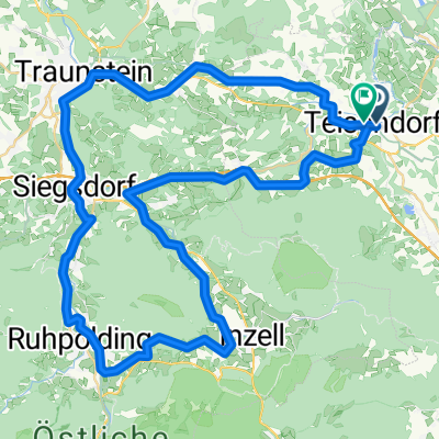
A cycling route starting in Teisendorf, Bavaria, Germany.
Overview
About this route
Rundweg über Waging nach Lauter und zurück zum Ausgangsort Oberteisendorf
- -:--
- Duration
- 35.8 km
- Distance
- 353 m
- Ascent
- 353 m
- Descent
- ---
- Avg. speed
- ---
- Avg. speed
Route quality
Waytypes & surfaces along the route
Waytypes
Quiet road
30.4 km
(85 %)
Access road
2.5 km
(7 %)
Surfaces
Paved
25.9 km
(72 %)
Asphalt
25.7 km
(72 %)
Paved (undefined)
0.2 km
(<1 %)
Undefined
9.9 km
(28 %)
Continue with Bikemap
Use, edit, or download this cycling route
You would like to ride Alpenvorland_Tour29_Waginger See or customize it for your own trip? Here is what you can do with this Bikemap route:
Free features
- Save this route as favorite or in collections
- Copy & plan your own version of this route
- Sync your route with Garmin or Wahoo
Premium features
Free trial for 3 days, or one-time payment. More about Bikemap Premium.
- Navigate this route on iOS & Android
- Export a GPX / KML file of this route
- Create your custom printout (try it for free)
- Download this route for offline navigation
Discover more Premium features.
Get Bikemap PremiumFrom our community
Other popular routes starting in Teisendorf
- Stoißeralm
- Distance
- 26.4 km
- Ascent
- 795 m
- Descent
- 795 m
- Location
- Teisendorf, Bavaria, Germany
- test
- Distance
- 20.1 km
- Ascent
- 153 m
- Descent
- 194 m
- Location
- Teisendorf, Bavaria, Germany
- Ibm-Runde
- Distance
- 109.6 km
- Ascent
- 1,193 m
- Descent
- 1,227 m
- Location
- Teisendorf, Bavaria, Germany
- 2015_Teisendorf_Freilassing
- Distance
- 44.1 km
- Ascent
- 100 m
- Descent
- 181 m
- Location
- Teisendorf, Bavaria, Germany
- Variante um den Waginger und Tachinger See
- Distance
- 64.4 km
- Ascent
- 591 m
- Descent
- 579 m
- Location
- Teisendorf, Bavaria, Germany
- Stoißeralm
- Distance
- 26.3 km
- Ascent
- 1,098 m
- Descent
- 993 m
- Location
- Teisendorf, Bavaria, Germany
- 2016_2_Königssee - Bodensee (Teisendorf - Aschau)
- Distance
- 72 km
- Ascent
- 674 m
- Descent
- 574 m
- Location
- Teisendorf, Bavaria, Germany
- Tsdf Traunstein Teisenberg
- Distance
- 34.7 km
- Ascent
- 363 m
- Descent
- 363 m
- Location
- Teisendorf, Bavaria, Germany
Open it in the app