

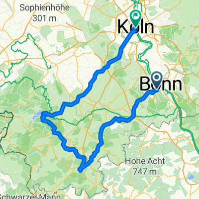
BRT2016-FR: An Rhein und Sieg - PSF des Radsportbezirk Mittelrhein-Süd beim BRT 2016 in Bonn - 76 km Strecke
A cycling route starting in Bonn, North Rhine-Westphalia, Germany.
Overview
About this route
BRT2016-FR: An Rhein und Sieg - 76 km
PSF (Pfeil-Such-Fahrt) des Radsportbezirk Mittelrhein-Süd beim BRT 2016 in Bonn
Alle weiteren Hinweise zu dieser Strecke -> hier anklicken
- -:--
- Duration
- 74.9 km
- Distance
- 509 m
- Ascent
- 509 m
- Descent
- ---
- Avg. speed
- ---
- Max. altitude

Route quality
Waytypes & surfaces along the route
Waytypes
Busy road
25 km
(33 %)
Quiet road
14.5 km
(19 %)
Surfaces
Paved
56.8 km
(76 %)
Unpaved
0.1 km
(<1 %)
Asphalt
53.1 km
(71 %)
Paved (undefined)
1.3 km
(2 %)
Route highlights
Points of interest along the route

Drinking water after 19.2 km
Kontrolle <b>Grafenwerth</b>
Point of interest after 33.5 km
Hier wieder eine Stelle, die unzureichend ausgeschildert wurde. Ein Glück, wer diese Einfahrt rechtzeitig gesehen hat.
Point of interest after 43.6 km
Auch hier wieder ein Pfeil nach dem Abzweig angebracht, den man zudem nicht sehen mußte. Im GPS-Track vom Veranstalter war der Schwenk ebenfalls nciht drin, sondern führte durch die Hauptstraße.

Drinking water after 43.8 km
Kontrolle <b>Asbach</b><br> die erst einmal gefunden werden will.
Continue with Bikemap
Use, edit, or download this cycling route
You would like to ride BRT2016-FR: An Rhein und Sieg - PSF des Radsportbezirk Mittelrhein-Süd beim BRT 2016 in Bonn - 76 km Strecke or customize it for your own trip? Here is what you can do with this Bikemap route:
Free features
- Save this route as favorite or in collections
- Copy & plan your own version of this route
- Sync your route with Garmin or Wahoo
Premium features
Free trial for 3 days, or one-time payment. More about Bikemap Premium.
- Navigate this route on iOS & Android
- Export a GPX / KML file of this route
- Create your custom printout (try it for free)
- Download this route for offline navigation
Discover more Premium features.
Get Bikemap PremiumFrom our community
Other popular routes starting in Bonn
 Auf den Feldern zwischen Köln und Troisdorf
- Distance
- 29.5 km
- Ascent
- 23 m
- Descent
- 24 m
- Location
- Bonn, North Rhine-Westphalia, Germany
 Bonn - Stadt Blankenberg
- Distance
- 79.5 km
- Ascent
- 846 m
- Descent
- 846 m
- Location
- Bonn, North Rhine-Westphalia, Germany
 BRT2016-MI: In den Westerwald - PSF des Radsportbezirk Mittelrhein-Süd beim BRT 2016 in Bonn - 70 km Strecke
- Distance
- 76.8 km
- Ascent
- 561 m
- Descent
- 561 m
- Location
- Bonn, North Rhine-Westphalia, Germany
 BRT2016-FR: An Rhein und Sieg - PSF des Radsportbezirk Mittelrhein-Süd beim BRT 2016 in Bonn - 76 km Strecke
- Distance
- 74.9 km
- Ascent
- 509 m
- Descent
- 509 m
- Location
- Bonn, North Rhine-Westphalia, Germany
 Ahrtal-Eifel-Kottenforst
- Distance
- 80.9 km
- Ascent
- 925 m
- Descent
- 910 m
- Location
- Bonn, North Rhine-Westphalia, Germany
 Bonn - Ahrquelle - Rursee - Köln
- Distance
- 154 km
- Ascent
- 987 m
- Descent
- 1,006 m
- Location
- Bonn, North Rhine-Westphalia, Germany
 T-Mobile-Rheinauen-Mehlem-Köwi-Dollendorf-Rheinauen-T-Mobile
- Distance
- 15.6 km
- Ascent
- 50 m
- Descent
- 50 m
- Location
- Bonn, North Rhine-Westphalia, Germany
 Flach um Bonn
- Distance
- 56.6 km
- Ascent
- 186 m
- Descent
- 186 m
- Location
- Bonn, North Rhine-Westphalia, Germany
Open it in the app