

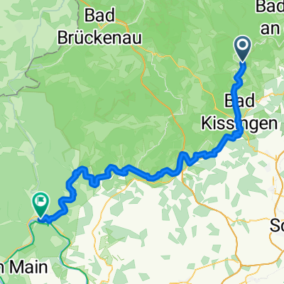
Bad Bocklet bis Lohr am Main
A cycling route starting in Bad Bocklet, Bavaria, Germany.
Overview
About this route
Along the Franconian Saale from Bad Bocklet to Lohr am Main
- -:--
- Duration
- 87.2 km
- Distance
- 262 m
- Ascent
- 309 m
- Descent
- ---
- Avg. speed
- ---
- Max. altitude

Route quality
Waytypes & surfaces along the route
Waytypes
Track
27.9 km
(32 %)
Quiet road
20.1 km
(23 %)
Surfaces
Paved
55.8 km
(64 %)
Unpaved
14 km
(16 %)
Asphalt
47.1 km
(54 %)
Gravel
8.7 km
(10 %)
Continue with Bikemap
Use, edit, or download this cycling route
You would like to ride Bad Bocklet bis Lohr am Main or customize it for your own trip? Here is what you can do with this Bikemap route:
Free features
- Save this route as favorite or in collections
- Copy & plan your own version of this route
- Split it into stages to create a multi-day tour
- Sync your route with Garmin or Wahoo
Premium features
Free trial for 3 days, or one-time payment. More about Bikemap Premium.
- Navigate this route on iOS & Android
- Export a GPX / KML file of this route
- Create your custom printout (try it for free)
- Download this route for offline navigation
Discover more Premium features.
Get Bikemap PremiumFrom our community
Other popular routes starting in Bad Bocklet
 Aschach - Kreuzberg - Aschach
- Distance
- 55.3 km
- Ascent
- 959 m
- Descent
- 956 m
- Location
- Bad Bocklet, Bavaria, Germany
 Dionysiusstraße 6, Bad Kissingen nach Dionysiusstraße 1, Bad Kissingen
- Distance
- 14.8 km
- Ascent
- 263 m
- Descent
- 263 m
- Location
- Bad Bocklet, Bavaria, Germany
 Rund um den Kreutzberg
- Distance
- 68.6 km
- Ascent
- 1,156 m
- Descent
- 1,147 m
- Location
- Bad Bocklet, Bavaria, Germany
 Drei-Täler-Tour durch die Südrhön
- Distance
- 25.8 km
- Ascent
- 213 m
- Descent
- 213 m
- Location
- Bad Bocklet, Bavaria, Germany
 Jakobsweg windheim - Saint Pied de port
- Distance
- 1,812.4 km
- Ascent
- 2,272 m
- Descent
- 2,459 m
- Location
- Bad Bocklet, Bavaria, Germany
 1. Tag Bad Bocklet - Hildburghausen
- Distance
- 75.2 km
- Ascent
- 391 m
- Descent
- 230 m
- Location
- Bad Bocklet, Bavaria, Germany
 Bad Bocklet - Waldsassen
- Distance
- 468.3 km
- Ascent
- 1,568 m
- Descent
- 1,573 m
- Location
- Bad Bocklet, Bavaria, Germany
 Tag 1 2019 - Bad Bocklet/Gemünden
- Distance
- 64.2 km
- Ascent
- 214 m
- Descent
- 278 m
- Location
- Bad Bocklet, Bavaria, Germany
Open it in the app