

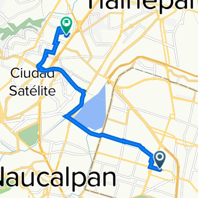
Acalapa - Salinillas
A cycling route starting in Azcapotzalco, Mexico City, Mexico.
Overview
About this route
From Argentina onwards, everything is uphill.
- 33 min
- Duration
- 7.4 km
- Distance
- 57 m
- Ascent
- 12 m
- Descent
- 13.5 km/h
- Avg. speed
- ---
- Max. altitude

Route quality
Waytypes & surfaces along the route
Waytypes
Quiet road
3.3 km
(44 %)
Cycleway
1.4 km
(19 %)
Surfaces
Paved
7 km
(94 %)
Asphalt
6.7 km
(90 %)
Concrete
0.3 km
(4 %)
Undefined
0.4 km
(6 %)
Continue with Bikemap
Use, edit, or download this cycling route
You would like to ride Acalapa - Salinillas or customize it for your own trip? Here is what you can do with this Bikemap route:
Free features
- Save this route as favorite or in collections
- Copy & plan your own version of this route
- Sync your route with Garmin or Wahoo
Premium features
Free trial for 3 days, or one-time payment. More about Bikemap Premium.
- Navigate this route on iOS & Android
- Export a GPX / KML file of this route
- Create your custom printout (try it for free)
- Download this route for offline navigation
Discover more Premium features.
Get Bikemap PremiumFrom our community
Other popular routes starting in Azcapotzalco
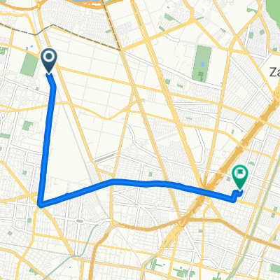
 Calzada San Isidro Tecpatl 143, Azcapotzalco a Ex Hacienda De Santa Monica, Tlalnepantla de baz
- Distance
- 10.6 km
- Ascent
- 63 m
- Descent
- 19 m
- Location
- Azcapotzalco, Mexico City, Mexico
 Avenida 22 de Febrero, Azcapotzalco a Calle Cedros, Azcapotzalco
- Distance
- 28.1 km
- Ascent
- 120 m
- Descent
- 115 m
- Location
- Azcapotzalco, Mexico City, Mexico
 De Isla del Socorro 93, Tlalnepantla de Baz a Isla del Socorro 92, Tlalnepantla de Baz
- Distance
- 15.5 km
- Ascent
- 248 m
- Descent
- 245 m
- Location
- Azcapotzalco, Mexico City, Mexico
 camino 1
- Distance
- 7.2 km
- Ascent
- 35 m
- Descent
- 40 m
- Location
- Azcapotzalco, Mexico City, Mexico
 Acalapa - Salinillas
- Distance
- 7.4 km
- Ascent
- 57 m
- Descent
- 12 m
- Location
- Azcapotzalco, Mexico City, Mexico
 Gesta Heroica
- Distance
- 13.5 km
- Ascent
- ---
- Descent
- ---
- Location
- Azcapotzalco, Mexico City, Mexico
 mi primer rodada
- Distance
- 25.7 km
- Ascent
- 135 m
- Descent
- 132 m
- Location
- Azcapotzalco, Mexico City, Mexico
 arena CDMX
- Distance
- 8.6 km
- Ascent
- 36 m
- Descent
- 36 m
- Location
- Azcapotzalco, Mexico City, Mexico
Open it in the app