

20160210_131816.gpx
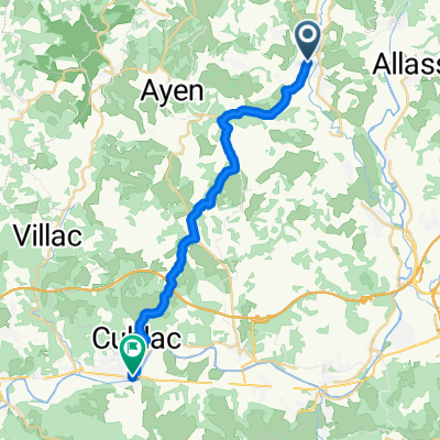
A cycling route starting in Objat, Nouvelle-Aquitaine, France.
Overview
About this route
TEASI track
- -:--
- Duration
- 16.4 km
- Distance
- 403 m
- Ascent
- 405 m
- Descent
- ---
- Avg. speed
- ---
- Max. altitude
Continue with Bikemap
Use, edit, or download this cycling route
You would like to ride 20160210_131816.gpx or customize it for your own trip? Here is what you can do with this Bikemap route:
Free features
- Save this route as favorite or in collections
- Copy & plan your own version of this route
- Sync your route with Garmin or Wahoo
Premium features
Free trial for 3 days, or one-time payment. More about Bikemap Premium.
- Navigate this route on iOS & Android
- Export a GPX / KML file of this route
- Create your custom printout (try it for free)
- Download this route for offline navigation
Discover more Premium features.
Get Bikemap PremiumFrom our community
Other popular routes starting in Objat
 circuit des momo
- Distance
- 76.8 km
- Ascent
- 1,014 m
- Descent
- 1,014 m
- Location
- Objat, Nouvelle-Aquitaine, France
 Recording from 27 juillet 16:57
- Distance
- 5.5 km
- Ascent
- 50 m
- Descent
- 22 m
- Location
- Objat, Nouvelle-Aquitaine, France
 109–145 Rue de l’Ancienne Gare, Perpezac-le-Blanc à 109–145 Rue de l’Ancienne Gare, Perpezac-le-Blanc
- Distance
- 6.7 km
- Ascent
- 94 m
- Descent
- 98 m
- Location
- Objat, Nouvelle-Aquitaine, France
 sortie entrainement
- Distance
- 116.7 km
- Ascent
- 749 m
- Descent
- 734 m
- Location
- Objat, Nouvelle-Aquitaine, France
 terrasson
- Distance
- 21.5 km
- Ascent
- 377 m
- Descent
- 417 m
- Location
- Objat, Nouvelle-Aquitaine, France
 Randonnée gastronomique 13/03/2016
- Distance
- 14 km
- Ascent
- 363 m
- Descent
- 366 m
- Location
- Objat, Nouvelle-Aquitaine, France
 6 Route d'Objat, Saint-Cyr-la-Roche à 6 Route d'Objat, Saint-Cyr-la-Roche
- Distance
- 35.4 km
- Ascent
- 739 m
- Descent
- 736 m
- Location
- Objat, Nouvelle-Aquitaine, France
 vtt 1
vtt 1- Distance
- 31.4 km
- Ascent
- 732 m
- Descent
- 731 m
- Location
- Objat, Nouvelle-Aquitaine, France
Open it in the app