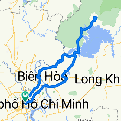
Quận Chin Đĩ Quân Mười Hai Đĩ Hoàng Sa
A cycling route starting in Quận Bình Thạnh, Ho Chi Minh City, Vietnam.
Overview
About this route
- 2 h 44 min
- Duration
- 51.5 km
- Distance
- 108 m
- Ascent
- 108 m
- Descent
- 18.8 km/h
- Avg. speed
- ---
- Avg. speed
Route quality
Waytypes & surfaces along the route
Waytypes
Undefined
51.5 km
(100 %)
Surfaces
Undefined
51.5 km
(100 %)
Route highlights
Points of interest along the route
Point of interest after 13.7 km
Point of interest after 16.3 km
Continue with Bikemap
Use, edit, or download this cycling route
You would like to ride Quận Chin Đĩ Quân Mười Hai Đĩ Hoàng Sa or customize it for your own trip? Here is what you can do with this Bikemap route:
Free features
- Save this route as favorite or in collections
- Copy & plan your own version of this route
- Sync your route with Garmin or Wahoo
Premium features
Free trial for 3 days, or one-time payment. More about Bikemap Premium.
- Navigate this route on iOS & Android
- Export a GPX / KML file of this route
- Create your custom printout (try it for free)
- Download this route for offline navigation
Discover more Premium features.
Get Bikemap PremiumFrom our community
Other popular routes starting in Quận Bình Thạnh
- Quận Chin Đĩ Quân Mười Hai Đĩ Hoàng Sa
- Distance
- 51.5 km
- Ascent
- 108 m
- Descent
- 108 m
- Location
- Quận Bình Thạnh, Ho Chi Minh City, Vietnam
- VNM HCMC-Cat Lai-Nhon Trach-Cat Lai-HCMC (119km)
- Distance
- 118.5 km
- Ascent
- 67 m
- Descent
- 66 m
- Location
- Quận Bình Thạnh, Ho Chi Minh City, Vietnam
- VNM HCMC-Phu My Bridge-Idiot Circle (64km)
- Distance
- 64 km
- Ascent
- 24 m
- Descent
- 27 m
- Location
- Quận Bình Thạnh, Ho Chi Minh City, Vietnam
- VNM HCMC-Ho Tram
- Distance
- 250.7 km
- Ascent
- 229 m
- Descent
- 230 m
- Location
- Quận Bình Thạnh, Ho Chi Minh City, Vietnam
- VNM HCMC-Le Minh Xuan-Idiot Circle-HCMC (104km)
- Distance
- 104.5 km
- Ascent
- 35 m
- Descent
- 39 m
- Location
- Quận Bình Thạnh, Ho Chi Minh City, Vietnam
- VNM - #1 of 8 HCMC-Mui Ne
- Distance
- 258.8 km
- Ascent
- 321 m
- Descent
- 313 m
- Location
- Quận Bình Thạnh, Ho Chi Minh City, Vietnam
- Saigon Bridge to Ao Dai Museum | Router for bicycle
- Distance
- 21.6 km
- Ascent
- 10 m
- Descent
- 12 m
- Location
- Quận Bình Thạnh, Ho Chi Minh City, Vietnam
- Nhieu Loc Canal
- Distance
- 18 km
- Ascent
- 101 m
- Descent
- 103 m
- Location
- Quận Bình Thạnh, Ho Chi Minh City, Vietnam