
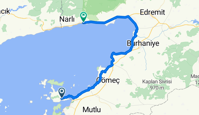
Cunda-Altınoluk 67km
A cycling route starting in Ayvalık, Balıkesir Province, Turkey.
Overview
About this route
Hiç yokuşun olmadığı tur bölge tamamen kalabalıklaşıp araç trafiği artmadan bahar ayları için ideal.
- -:--
- Duration
- 67.7 km
- Distance
- 142 m
- Ascent
- 160 m
- Descent
- ---
- Avg. speed
- ---
- Avg. speed
Continue with Bikemap
Use, edit, or download this cycling route
You would like to ride Cunda-Altınoluk 67km or customize it for your own trip? Here is what you can do with this Bikemap route:
Free features
- Save this route as favorite or in collections
- Copy & plan your own version of this route
- Sync your route with Garmin or Wahoo
Premium features
Free trial for 3 days, or one-time payment. More about Bikemap Premium.
- Navigate this route on iOS & Android
- Export a GPX / KML file of this route
- Create your custom printout (try it for free)
- Download this route for offline navigation
Discover more Premium features.
Get Bikemap PremiumFrom our community
Other popular routes starting in Ayvalık
 ultimate cunda
- Distance
- 25.7 km
- Ascent
- 519 m
- Descent
- 519 m
- Location
- Ayvalık, Balıkesir Province, Turkey
 Hamit Ağa Caddesi to Denizköy 6. Sokak 12
- Distance
- 55.5 km
- Ascent
- 445 m
- Descent
- 470 m
- Location
- Ayvalık, Balıkesir Province, Turkey
 Cunda Kültür Rotası
- Distance
- 12.9 km
- Ascent
- 186 m
- Descent
- 184 m
- Location
- Ayvalık, Balıkesir Province, Turkey
 şeytan
- Distance
- 1.8 km
- Ascent
- 112 m
- Descent
- 0 m
- Location
- Ayvalık, Balıkesir Province, Turkey
 For Summer
- Distance
- 401 km
- Ascent
- 963 m
- Descent
- 962 m
- Location
- Ayvalık, Balıkesir Province, Turkey
 Cunda-Altınoluk 67km
- Distance
- 67.7 km
- Ascent
- 142 m
- Descent
- 160 m
- Location
- Ayvalık, Balıkesir Province, Turkey
 AYVALIK KÜÇÜKKUYU
- Distance
- 75.7 km
- Ascent
- 201 m
- Descent
- 202 m
- Location
- Ayvalık, Balıkesir Province, Turkey
 CUNDA
CUNDA- Distance
- 29.8 km
- Ascent
- 307 m
- Descent
- 307 m
- Location
- Ayvalık, Balıkesir Province, Turkey
Open it in the app