
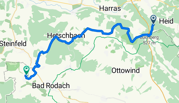
Eisfeld - Bad Rodach
A cycling route starting in Bockstadt, Thuringia, Germany.
Overview
About this route
Start: Eisfeld - Waldhotel Hubertus
Ziel: Bad Rodach - Land und Aktivhotel Altmühlaue- -:--
- Duration
- 21.5 km
- Distance
- 229 m
- Ascent
- 399 m
- Descent
- ---
- Avg. speed
- ---
- Max. altitude
Route quality
Waytypes & surfaces along the route
Waytypes
Track
17.4 km
(81 %)
Road
1.9 km
(9 %)
Surfaces
Paved
2.8 km
(13 %)
Unpaved
15.5 km
(72 %)
Ground
14.8 km
(69 %)
Asphalt
1.7 km
(8 %)
Continue with Bikemap
Use, edit, or download this cycling route
You would like to ride Eisfeld - Bad Rodach or customize it for your own trip? Here is what you can do with this Bikemap route:
Free features
- Save this route as favorite or in collections
- Copy & plan your own version of this route
- Sync your route with Garmin or Wahoo
Premium features
Free trial for 3 days, or one-time payment. More about Bikemap Premium.
- Navigate this route on iOS & Android
- Export a GPX / KML file of this route
- Create your custom printout (try it for free)
- Download this route for offline navigation
Discover more Premium features.
Get Bikemap PremiumFrom our community
Other popular routes starting in Bockstadt
 Grenzerfahrungen Teil 03 #BETA#
- Distance
- 119.1 km
- Ascent
- 571 m
- Descent
- 660 m
- Location
- Bockstadt, Thuringia, Germany
 Werra Main Verbindung
- Distance
- 43.2 km
- Ascent
- 307 m
- Descent
- 480 m
- Location
- Bockstadt, Thuringia, Germany
 Harras-Loffeld
- Distance
- 46.5 km
- Ascent
- 263 m
- Descent
- 410 m
- Location
- Bockstadt, Thuringia, Germany
 Eisfeld - Bad Rodach
- Distance
- 21.5 km
- Ascent
- 229 m
- Descent
- 399 m
- Location
- Bockstadt, Thuringia, Germany
 Thuringia 01: Eisfeld - Schmalkalden
- Distance
- 85.6 km
- Ascent
- 232 m
- Descent
- 407 m
- Location
- Bockstadt, Thuringia, Germany
 Bockstadt - Breitungen
- Distance
- 84.4 km
- Ascent
- 301 m
- Descent
- 486 m
- Location
- Bockstadt, Thuringia, Germany
 Harras Runde
- Distance
- 16.2 km
- Ascent
- 274 m
- Descent
- 274 m
- Location
- Bockstadt, Thuringia, Germany
 Thüringer Wald
- Distance
- 92.7 km
- Ascent
- 746 m
- Descent
- 954 m
- Location
- Bockstadt, Thuringia, Germany
Open it in the app