

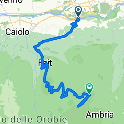
Decouville delle Orobie Valtellinesi - da Albosaggia Porto
A cycling route starting in Torchione-Moia, Lombardy, Italy.
Overview
About this route
Panoramico itinerario che con diverse difficoltà tra salita , attraversata e discesa divertente permette di percorrere la vecchia strada un tempo con binari per carrelli di collegamento tra tre centrali e bacini idroelettrici alla quota di 1000 m. Il percorso, inizialmente su Sentiero Valtellina fino alla passerella che porta a Faedo e poi a Busteggia,comincia a salire fino alla centrale di Vedello. Da qui per 14Km il percorso è tutto in piano e attraversa tre valli. Inizialmente in gallerie scavate nella roccia e poi in boschi di larici e abeti. Arrivati ad alla centrale di Armisa si scende da sentiero, si attraversa il torrente Armisa e tra strada e poi di nuovo su sentiero si arriva a Bruga. Si riprende il Sentiero Valtellina e si ritorna ad Albosaggia
- -:--
- Duration
- 41.4 km
- Distance
- 911 m
- Ascent
- 904 m
- Descent
- ---
- Avg. speed
- ---
- Max. altitude
Continue with Bikemap
Use, edit, or download this cycling route
You would like to ride Decouville delle Orobie Valtellinesi - da Albosaggia Porto or customize it for your own trip? Here is what you can do with this Bikemap route:
Free features
- Save this route as favorite or in collections
- Copy & plan your own version of this route
- Sync your route with Garmin or Wahoo
Premium features
Free trial for 3 days, or one-time payment. More about Bikemap Premium.
- Navigate this route on iOS & Android
- Export a GPX / KML file of this route
- Create your custom printout (try it for free)
- Download this route for offline navigation
Discover more Premium features.
Get Bikemap PremiumFrom our community
Other popular routes starting in Torchione-Moia
 Sondrio - Colico 12.9.2018
- Distance
- 45 km
- Ascent
- 112 m
- Descent
- 200 m
- Location
- Torchione-Moia, Lombardy, Italy
 Sentiero Rusca da Albosaggia a Chiesa in Valmalenco
- Distance
- 18.2 km
- Ascent
- 736 m
- Descent
- 46 m
- Location
- Torchione-Moia, Lombardy, Italy
 Von Sondrio bis Piateda
- Distance
- 19.8 km
- Ascent
- 2,353 m
- Descent
- 520 m
- Location
- Torchione-Moia, Lombardy, Italy
 Decouville delle Orobie Valtellinesi - da Albosaggia Porto
- Distance
- 41.4 km
- Ascent
- 911 m
- Descent
- 904 m
- Location
- Torchione-Moia, Lombardy, Italy
 sondrio - lanzada
- Distance
- 20.4 km
- Ascent
- 879 m
- Descent
- 193 m
- Location
- Torchione-Moia, Lombardy, Italy
 Sondrio - Tirano ebike
- Distance
- 64.5 km
- Ascent
- 635 m
- Descent
- 635 m
- Location
- Torchione-Moia, Lombardy, Italy
 Sondrio-Colico Ciclabile Valtellina
- Distance
- 46.1 km
- Ascent
- 48 m
- Descent
- 123 m
- Location
- Torchione-Moia, Lombardy, Italy
 Percorso moderato in Sondrio
- Distance
- 11.6 km
- Ascent
- 99 m
- Descent
- 99 m
- Location
- Torchione-Moia, Lombardy, Italy
Open it in the app