

KDŠ_27_2018
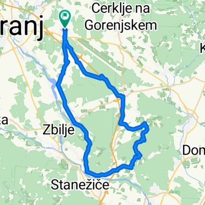
A cycling route starting in Šenčur, Občina Šenčur, Slovenia.
Overview
About this route
Šenčur - Voklo - Trboje - Smlednik - Tacen - Srednje Gameljne - Rašica - Selo pri Vodicah - Polje - Vodice - Voglje - Šenčur
- -:--
- Duration
- 42 km
- Distance
- 379 m
- Ascent
- 379 m
- Descent
- ---
- Avg. speed
- ---
- Max. altitude

Route quality
Waytypes & surfaces along the route
Waytypes
Quiet road
16.8 km
(40 %)
Road
13 km
(31 %)
Surfaces
Paved
29.8 km
(71 %)
Unpaved
5.9 km
(14 %)
Asphalt
25.6 km
(61 %)
Gravel
5.9 km
(14 %)
Continue with Bikemap
Use, edit, or download this cycling route
You would like to ride KDŠ_27_2018 or customize it for your own trip? Here is what you can do with this Bikemap route:
Free features
- Save this route as favorite or in collections
- Copy & plan your own version of this route
- Sync your route with Garmin or Wahoo
Premium features
Free trial for 3 days, or one-time payment. More about Bikemap Premium.
- Navigate this route on iOS & Android
- Export a GPX / KML file of this route
- Create your custom printout (try it for free)
- Download this route for offline navigation
Discover more Premium features.
Get Bikemap PremiumFrom our community
Other popular routes starting in Šenčur
 Maraton Karavanke I
- Distance
- 132.5 km
- Ascent
- 2,010 m
- Descent
- 2,010 m
- Location
- Šenčur, Občina Šenčur, Slovenia
 LSD Day 1
- Distance
- 133.7 km
- Ascent
- 1,219 m
- Descent
- 1,450 m
- Location
- Šenčur, Občina Šenčur, Slovenia
 zbilje - 2020
- Distance
- 37.4 km
- Ascent
- 105 m
- Descent
- 105 m
- Location
- Šenčur, Občina Šenčur, Slovenia
 Kolesarjenje po občini šenčur
- Distance
- 25.5 km
- Ascent
- 104 m
- Descent
- 133 m
- Location
- Šenčur, Občina Šenčur, Slovenia
 Šenčur–Trboje–Šenčur
- Distance
- 19.4 km
- Ascent
- 124 m
- Descent
- 124 m
- Location
- Šenčur, Občina Šenčur, Slovenia
 KD Šenčur - Po Sloveniji 2009 - 1.etapa
- Distance
- 156.6 km
- Ascent
- 2,478 m
- Descent
- 2,721 m
- Location
- Šenčur, Občina Šenčur, Slovenia
 KDŠ_02_2018
- Distance
- 38.7 km
- Ascent
- 252 m
- Descent
- 255 m
- Location
- Šenčur, Občina Šenčur, Slovenia
 KDŠ_27_2018
- Distance
- 42 km
- Ascent
- 379 m
- Descent
- 379 m
- Location
- Šenčur, Občina Šenčur, Slovenia
Open it in the app