Die Wolfstour (Nord-Route)
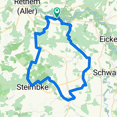
A cycling route starting in Frankenfeld, Lower Saxony, Germany.
Overview
About this route
The cycling route (north route) through the municipalities of Heemsen, Grafschaft Hoya, Rethem, and the town of Ahlden (Aller).
- -:--
- Duration
- 47.2 km
- Distance
- 73 m
- Ascent
- 73 m
- Descent
- ---
- Avg. speed
- ---
- Max. altitude
Route quality
Waytypes & surfaces along the route
Waytypes
Quiet road
13.7 km
(29 %)
Track
10.9 km
(23 %)
Surfaces
Paved
19.8 km
(42 %)
Unpaved
12.7 km
(27 %)
Asphalt
12.7 km
(27 %)
Unpaved (undefined)
6.1 km
(13 %)
Route highlights
Points of interest along the route
Point of interest after 0.9 km
NaturWaldBad Steimbke
Point of interest after 5.9 km
Jägerkrug Sonnenborstel
Point of interest after 9.8 km
Hämelsee
Point of interest after 20.9 km
Wolfcenter Dörverden
Point of interest after 44.5 km
Naturerlebnisbad Rodewald
Point of interest after 44.5 km
Reisemobilstellplatz Rodewald
Continue with Bikemap
Use, edit, or download this cycling route
You would like to ride Die Wolfstour (Nord-Route) or customize it for your own trip? Here is what you can do with this Bikemap route:
Free features
- Save this route as favorite or in collections
- Copy & plan your own version of this route
- Sync your route with Garmin or Wahoo
Premium features
Free trial for 3 days, or one-time payment. More about Bikemap Premium.
- Navigate this route on iOS & Android
- Export a GPX / KML file of this route
- Create your custom printout (try it for free)
- Download this route for offline navigation
Discover more Premium features.
Get Bikemap PremiumFrom our community
Other popular routes starting in Frankenfeld
- Recovered Route
- Distance
- 13.1 km
- Ascent
- 0 m
- Descent
- 3 m
- Location
- Frankenfeld, Lower Saxony, Germany
- Einfache Fahrt in Frankenfeld
- Distance
- 6.5 km
- Ascent
- 0 m
- Descent
- 0 m
- Location
- Frankenfeld, Lower Saxony, Germany
- Allerhof zum Reiterhof Hagedorn Steimbke
- Distance
- 9.7 km
- Ascent
- 36 m
- Descent
- 31 m
- Location
- Frankenfeld, Lower Saxony, Germany
- Die Wolfstour (Nord-Route)
- Distance
- 47.2 km
- Ascent
- 73 m
- Descent
- 73 m
- Location
- Frankenfeld, Lower Saxony, Germany
- Frankenfeld(Aller) Denkmal nach Am Hohen Ufer 3A
- Distance
- 62.1 km
- Ascent
- 170 m
- Descent
- 135 m
- Location
- Frankenfeld, Lower Saxony, Germany
- 50Km_Bosse_Lichtenmoor_Frankenfeld
- Distance
- 50.9 km
- Ascent
- 61 m
- Descent
- 62 m
- Location
- Frankenfeld, Lower Saxony, Germany
- Bosse / Aller - Schneverdingen, ca. 72 km
- Distance
- 72.1 km
- Ascent
- 354 m
- Descent
- 298 m
- Location
- Frankenfeld, Lower Saxony, Germany
- Rodewalder Straße 367, Rethem (Aller) nach Rodewalder Straße 367, Rethem (Aller)
- Distance
- 47.2 km
- Ascent
- 57 m
- Descent
- 60 m
- Location
- Frankenfeld, Lower Saxony, Germany
Open it in the app