

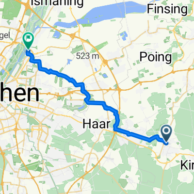
Zorneding Rundfahrt 44KM ab Hotel
A cycling route starting in Zorneding, Bavaria, Germany.
Overview
About this route
Beautiful circular tour with the Ebersberger Alm restaurant 160HM
- -:--
- Duration
- 44.1 km
- Distance
- 165 m
- Ascent
- 164 m
- Descent
- ---
- Avg. speed
- ---
- Max. altitude

Route quality
Waytypes & surfaces along the route
Waytypes
Track
16.7 km
(38 %)
Quiet road
15 km
(34 %)
Surfaces
Paved
23.4 km
(53 %)
Unpaved
19.8 km
(45 %)
Asphalt
23.4 km
(53 %)
Gravel
10.6 km
(24 %)
Continue with Bikemap
Use, edit, or download this cycling route
You would like to ride Zorneding Rundfahrt 44KM ab Hotel or customize it for your own trip? Here is what you can do with this Bikemap route:
Free features
- Save this route as favorite or in collections
- Copy & plan your own version of this route
- Sync your route with Garmin or Wahoo
Premium features
Free trial for 3 days, or one-time payment. More about Bikemap Premium.
- Navigate this route on iOS & Android
- Export a GPX / KML file of this route
- Create your custom printout (try it for free)
- Download this route for offline navigation
Discover more Premium features.
Get Bikemap PremiumFrom our community
Other popular routes starting in Zorneding
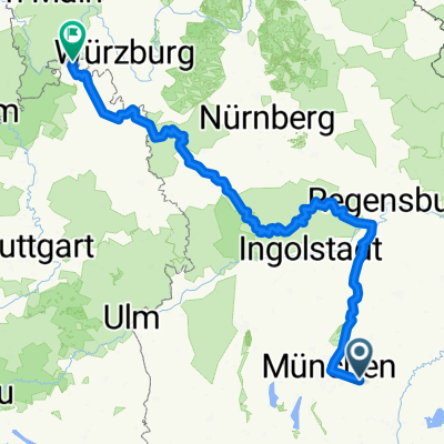
 Zorneding-Unterelkhofen
- Distance
- 57.1 km
- Ascent
- 350 m
- Descent
- 350 m
- Location
- Zorneding, Bavaria, Germany
 The best Route to Unterföhring
- Distance
- 22.7 km
- Ascent
- 31 m
- Descent
- 74 m
- Location
- Zorneding, Bavaria, Germany
 Panorama-Route bayr. Oberland
- Distance
- 55.8 km
- Ascent
- 630 m
- Descent
- 600 m
- Location
- Zorneding, Bavaria, Germany
 Zorneding-Isar Radweg - Altmuel Tauber Radweg_dolga
- Distance
- 481.6 km
- Ascent
- 3,653 m
- Descent
- 4,059 m
- Location
- Zorneding, Bavaria, Germany
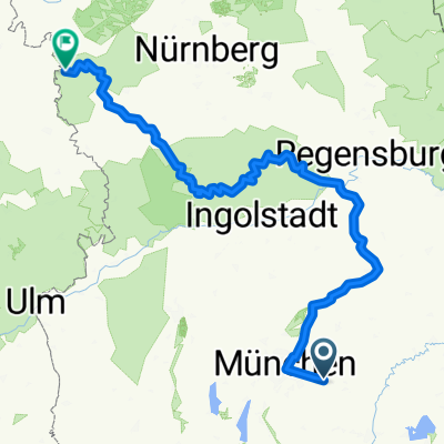
 Schnelle Runde Zorneding - Aßling - G'höhenrain
- Distance
- 45.6 km
- Ascent
- 576 m
- Descent
- 566 m
- Location
- Zorneding, Bavaria, Germany
 Zorneding-Isar Radweg - Altmuel Tauber Radweg
- Distance
- 407.9 km
- Ascent
- 2,093 m
- Descent
- 2,229 m
- Location
- Zorneding, Bavaria, Germany
 Erding
- Distance
- 63.8 km
- Ascent
- 127 m
- Descent
- 127 m
- Location
- Zorneding, Bavaria, Germany
 Mistelweg nach Fuchsweg
- Distance
- 12.5 km
- Ascent
- 51 m
- Descent
- 100 m
- Location
- Zorneding, Bavaria, Germany
Open it in the app