

SRW_Etappe1
A cycling route starting in Münchberg, Bavaria, Germany.
Overview
About this route
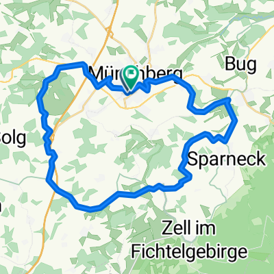
Münchberg - Zell
- -:--
- Duration
- 10.7 km
- Distance
- 168 m
- Ascent
- 86 m
- Descent
- ---
- Avg. speed
- ---
- Max. altitude

Route quality
Waytypes & surfaces along the route
Waytypes
Quiet road
3.6 km
(34 %)
Road
3.3 km
(31 %)
Surfaces
Paved
5.8 km
(54 %)
Unpaved
1 km
(9 %)
Asphalt
5.4 km
(50 %)
Gravel
0.8 km
(7 %)
Route highlights
Points of interest along the route

Photo after 6.8 km
Oberfränkisches Bauernmuseum

Accommodation after 10.7 km
Gasthof Rotes Ross Marktplatz 10 95239 Zell/Fichtelgebirge Tel.: 09257/1530
Continue with Bikemap
Use, edit, or download this cycling route
You would like to ride SRW_Etappe1 or customize it for your own trip? Here is what you can do with this Bikemap route:
Free features
- Save this route as favorite or in collections
- Copy & plan your own version of this route
- Sync your route with Garmin or Wahoo
Premium features
Free trial for 3 days, or one-time payment. More about Bikemap Premium.
- Navigate this route on iOS & Android
- Export a GPX / KML file of this route
- Create your custom printout (try it for free)
- Download this route for offline navigation
Discover more Premium features.
Get Bikemap PremiumFrom our community
Other popular routes starting in Münchberg
 26km um Münchberg herum
- Distance
- 26.5 km
- Ascent
- 252 m
- Descent
- 250 m
- Location
- Münchberg, Bavaria, Germany
 SRW_Etappe1
- Distance
- 10.7 km
- Ascent
- 168 m
- Descent
- 86 m
- Location
- Münchberg, Bavaria, Germany
 F 12.1 Von Münchberg, Bhf. zur Saalequelle
- Distance
- 11.1 km
- Ascent
- 242 m
- Descent
- 58 m
- Location
- Münchberg, Bavaria, Germany
 Rundtour ab Münchberg 1
- Distance
- 48.6 km
- Ascent
- 429 m
- Descent
- 430 m
- Location
- Münchberg, Bavaria, Germany
 Laubersreuth-Kulmbach
- Distance
- 36.8 km
- Ascent
- 169 m
- Descent
- 446 m
- Location
- Münchberg, Bavaria, Germany
 Amselweg, Münchberg nach Amselweg, Münchberg
- Distance
- 44 km
- Ascent
- 640 m
- Descent
- 640 m
- Location
- Münchberg, Bavaria, Germany
 Münchberg Rundtour 3
- Distance
- 41.2 km
- Ascent
- 376 m
- Descent
- 376 m
- Location
- Münchberg, Bavaria, Germany
 D-B 15 a Muenchberg - Rudolphstein
- Distance
- 49.4 km
- Ascent
- 355 m
- Descent
- 385 m
- Location
- Münchberg, Bavaria, Germany
Open it in the app