

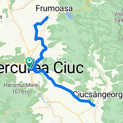
Erdély folytatás v2. ~ 500 km
A cycling route starting in Miercurea-Ciuc, Harghita County, Romania.
Overview
About this route
Csíkszereda - Marosvásárhely
- -:--
- Duration
- 522.3 km
- Distance
- 1,740 m
- Ascent
- 2,096 m
- Descent
- ---
- Avg. speed
- ---
- Max. altitude

Route quality
Waytypes & surfaces along the route
Waytypes
Quiet road
67.9 km
(13 %)
Cycleway
57.5 km
(11 %)
Surfaces
Paved
444 km
(85 %)
Unpaved
36.6 km
(7 %)
Asphalt
428.3 km
(82 %)
Gravel
20.9 km
(4 %)
Route highlights
Points of interest along the route

Point of interest after 0 km
Csíkszereda http://www.szereda.ro/
Point of interest after 0 km
Tusnád http://www.sohaztur.ro/tusnad.htm

Point of interest after 0.1 km
Tusnádfürdő - Szent Anna-tó http://www.szekelyfoldiinfo.ro/Menu/tusnadfurdo-prezentacio_kepekben-turisztikai_attrakciok-szallas-helyek-terkep-a_kornyek_turisztikai_latvanyossagai-szallasai-tusnadfurdo.html http://szentanna-to.ro/

Point of interest after 0.9 km
Székelyderzs - vártemplom http://szekelyderzs.com/templom.html

Point of interest after 1 km
Székelyudvarhely http://www.erdely-szep.hu/Szekelyudvarhely/index.html

Point of interest after 1 km
Homoródfürdő - 890m szállás: http://lobogo.ro/hu/ http://www.erdely-szep.hu/Homorodfurdo/index.html
Point of interest after 1.4 km
Madarasi-Hargita - 1801 m http://www.erdely-szep.hu/Madarasi-Hargita%203/index.html
Point of interest after 1.4 km
Hargita - 1400 m

Point of interest after 9.2 km
Gyergyószentmiklós http://www.erdely-szep.hu/Gyergyoszentmiklos/index.html
Point of interest after 33.4 km
Na itt nem biztos, hogy van út! :D

Point of interest after 33.4 km
Egyes kő (bringa nélküli) http://szepkilatas.blog.hu/2014/03/04/egyesko_a_szekelyfold_legszebb_orma

Point of interest after 33.5 km
Gyilkos-tó http://www.erdely-szep.hu/Gyilkos%20to/index.html
Point of interest after 36.9 km
http://muhos.ro/

Point of interest after 37.7 km
Békás-szoros http://www.erdely-szep.hu/Bekas%20szoros/index.html

Point of interest after 42.6 km
Gyimesbükk - 1000 éves magyar határ Deáky panzió http://www.erdely-szep.hu/Gyimesbukk/index.html
Point of interest after 477 km
Tordai hasadék
Point of interest after 477 km
Kolozsvár opció: Hargita IC - kerékpár -> Bp.
Point of interest after 477 km
Tordatúr - sziklák
Point of interest after 477 km
Torda - sóbánya
Point of interest after 477 km
Torockó

Point of interest after 515.6 km
Parajd (sóbánya) http://www.erdely-szep.hu/Parajd/index.html

Point of interest after 515.6 km
Szováta - Medve-tó http://www.erdely-szep.hu/Korond%20es%20Szovata/index.html
Point of interest after 515.6 km
Korond http://www.erdely-szep.hu/Korond%20es%20Szovata/index.html

Point of interest after 522.3 km
Nagyszeben http://www.erdely-szep.hu/Nagyszeben/index.html
Point of interest after 522.3 km
Marosvásárhely opció: Hargita IC - kerékpár -> BP.

Point of interest after 522.3 km
Kerc - cisztercita apátság http://www.erodtemplomok.ro/locations/carta___kerc/66/
Point of interest after 522.3 km
Medgyes (+ vár)

Point of interest after 522.3 km
Szelindek - vár http://www.erdely-szep.hu/Szelindek/index.html

Point of interest after 522.3 km
Fogaras - vár http://www.erdelyivarak.hu/magyar/oldalak/fogaras_vara/

Point of interest after 522.3 km
Fogarasi-havasok - 1900 m http://www.erdely-szep.hu/Transzfogaras/index.html
Point of interest after 522.3 km
Gyulafehérvár
Point of interest after 522.3 km
Patru Hotare-tó

Point of interest after 522.3 km
Segesvár http://www.erdely-szep.hu/Segesvar/index.html
Point of interest after 522.3 km
Déva (vár)
Continue with Bikemap
Use, edit, or download this cycling route
You would like to ride Erdély folytatás v2. ~ 500 km or customize it for your own trip? Here is what you can do with this Bikemap route:
Free features
- Save this route as favorite or in collections
- Copy & plan your own version of this route
- Split it into stages to create a multi-day tour
- Sync your route with Garmin or Wahoo
Premium features
Free trial for 3 days, or one-time payment. More about Bikemap Premium.
- Navigate this route on iOS & Android
- Export a GPX / KML file of this route
- Create your custom printout (try it for free)
- Download this route for offline navigation
Discover more Premium features.
Get Bikemap PremiumFrom our community
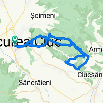
Other popular routes starting in Miercurea-Ciuc
 MTB 70km 2014
- Distance
- 66.7 km
- Ascent
- 1,579 m
- Descent
- 1,579 m
- Location
- Miercurea-Ciuc, Harghita County, Romania
 Race > Mtb > Miercurea Ciuc 2009
- Distance
- 39.8 km
- Ascent
- 1,076 m
- Descent
- 985 m
- Location
- Miercurea-Ciuc, Harghita County, Romania
 Ride Through
- Distance
- 28.1 km
- Ascent
- 249 m
- Descent
- 208 m
- Location
- Miercurea-Ciuc, Harghita County, Romania
 Kászoni körút
- Distance
- 78.1 km
- Ascent
- 934 m
- Descent
- 950 m
- Location
- Miercurea-Ciuc, Harghita County, Romania
 MTB 30km 2014
- Distance
- 33.8 km
- Ascent
- 879 m
- Descent
- 879 m
- Location
- Miercurea-Ciuc, Harghita County, Romania
 Bánkfalva-Csíkszentmiklós
- Distance
- 54.7 km
- Ascent
- 575 m
- Descent
- 575 m
- Location
- Miercurea-Ciuc, Harghita County, Romania
 Vasarnapi Gyimes kerulo
- Distance
- 82.6 km
- Ascent
- 1,247 m
- Descent
- 1,253 m
- Location
- Miercurea-Ciuc, Harghita County, Romania
 SZT / MTB CIUC 30 km semimaraton
- Distance
- 33.5 km
- Ascent
- 841 m
- Descent
- 841 m
- Location
- Miercurea-Ciuc, Harghita County, Romania
Open it in the app