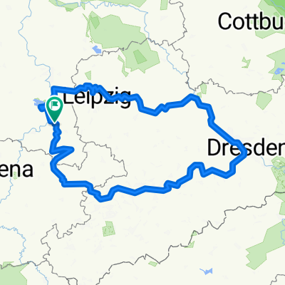
SRW_Etappe7
A cycling route starting in Weißenfels, Saxony-Anhalt, Germany.
Overview
About this route
Weißenfels - Wettin
- -:--
- Duration
- 68.8 km
- Distance
- 135 m
- Ascent
- 143 m
- Descent
- ---
- Avg. speed
- ---
- Avg. speed
Route quality
Waytypes & surfaces along the route
Waytypes
Quiet road
21.2 km
(31 %)
Path
14.2 km
(21 %)
Surfaces
Paved
54.2 km
(79 %)
Unpaved
8.4 km
(12 %)
Asphalt
47.5 km
(69 %)
Paving stones
4.1 km
(6 %)
Route highlights
Points of interest along the route
Point of interest after 1.5 km
Novalishaus
Point of interest after 1.6 km
Heinrich-Schütz-Haus
Point of interest after 1.7 km
Geleitshaus Gustav-Adolf-Museum
Point of interest after 1.7 km
Schloss Neu Augustusburg
Point of interest after 1.7 km
Schlosskapelle
Point of interest after 1.8 km
Rathaus
Point of interest after 1.8 km
Marienkirche
Point of interest after 16.5 km
Gradierwerk
Point of interest after 16.7 km
Borlachmuseum
Point of interest after 16.9 km
Kath. Kirche St. Bonifatius expressionistische Innenausstattung
Point of interest after 22.5 km
Plastikpark
Point of interest after 26.1 km
Ruine St. Sixti
Point of interest after 26.2 km
Tante Eva besuchen
Point of interest after 26.8 km
Altes Rathaus
Point of interest after 26.8 km
St. Maximi
Point of interest after 27.1 km
Willi-Sitte-Galerie
Point of interest after 27.1 km
Dom
Point of interest after 27.1 km
Neumarktkirche
Point of interest after 27.1 km
Schloss
Point of interest after 27.3 km
Ständehaus
Point of interest after 27.5 km
Obere Wasserkunst
Point of interest after 27.7 km
Petrikloster
Point of interest after 27.8 km
St. Veit
Point of interest after 31.5 km
Schloss
Point of interest after 31.7 km
Kirche
Point of interest after 46.4 km
Neue Residenz
Point of interest after 46.5 km
Wilhelm-Friedemann-Bach-Haus
Point of interest after 46.6 km
Göbelbrunnen
Point of interest after 46.6 km
Hallmarkt
Point of interest after 46.7 km
Drachenbrunnen
Point of interest after 46.8 km
Marktkirche Unserer Lieben Frauen
Point of interest after 46.8 km
Händel-Denkmal
Point of interest after 46.8 km
Stadthaus
Point of interest after 46.8 km
Roter Turm mit Roland
Point of interest after 47 km
Händelhaus
Point of interest after 47.2 km
Lebenskreis (Brunnen)
Point of interest after 47.2 km
Dom
Point of interest after 47.4 km
Moritzburg
Point of interest after 49.3 km
Burg Giebichenstein
Point of interest after 56.1 km
Brachwitzer Alpen
Point of interest after 64.5 km
Dorfkirche
Point of interest after 65.8 km
Loreley der Saale Aussichtspunkt
Point of interest after 66.7 km
Fahrradmuseum
Point of interest after 66.7 km
Templerkapelle
Point of interest after 67.5 km
Fürstenzug (Denkmal)
Point of interest after 68.4 km
Burg Stammsitz der Wettiner!
Continue with Bikemap
Use, edit, or download this cycling route
You would like to ride SRW_Etappe7 or customize it for your own trip? Here is what you can do with this Bikemap route:
Free features
- Save this route as favorite or in collections
- Copy & plan your own version of this route
- Sync your route with Garmin or Wahoo
Premium features
Free trial for 3 days, or one-time payment. More about Bikemap Premium.
- Navigate this route on iOS & Android
- Export a GPX / KML file of this route
- Create your custom printout (try it for free)
- Download this route for offline navigation
Discover more Premium features.
Get Bikemap PremiumFrom our community
Other popular routes starting in Weißenfels
- D11 cheat Weissenfels bis Grafenhainichen
- Distance
- 102.7 km
- Ascent
- 130 m
- Descent
- 136 m
- Location
- Weißenfels, Saxony-Anhalt, Germany
- Weißensfels - Bad Kösen
- Distance
- 30.8 km
- Ascent
- 119 m
- Descent
- 102 m
- Location
- Weißenfels, Saxony-Anhalt, Germany
- Zeitzer Gärten, Weißenfels nach Karl-Marx-Siedlung 49, Weißenfels
- Distance
- 8.5 km
- Ascent
- 84 m
- Descent
- 87 m
- Location
- Weißenfels, Saxony-Anhalt, Germany
- Weißenfels-Bad Kösen-Rehehausen-Apolda
- Distance
- 60.3 km
- Ascent
- 352 m
- Descent
- 271 m
- Location
- Weißenfels, Saxony-Anhalt, Germany
- WSF 002: Weißenfelsrunde 2
- Distance
- 93.3 km
- Ascent
- 347 m
- Descent
- 347 m
- Location
- Weißenfels, Saxony-Anhalt, Germany
- SRW_Etappe7
- Distance
- 68.8 km
- Ascent
- 135 m
- Descent
- 143 m
- Location
- Weißenfels, Saxony-Anhalt, Germany
- WSF 001: Weißenfelsrunde 1
- Distance
- 85.5 km
- Ascent
- 436 m
- Descent
- 436 m
- Location
- Weißenfels, Saxony-Anhalt, Germany
- Runde2025
- Distance
- 487.1 km
- Ascent
- 3,574 m
- Descent
- 3,573 m
- Location
- Weißenfels, Saxony-Anhalt, Germany
Open it in the app