
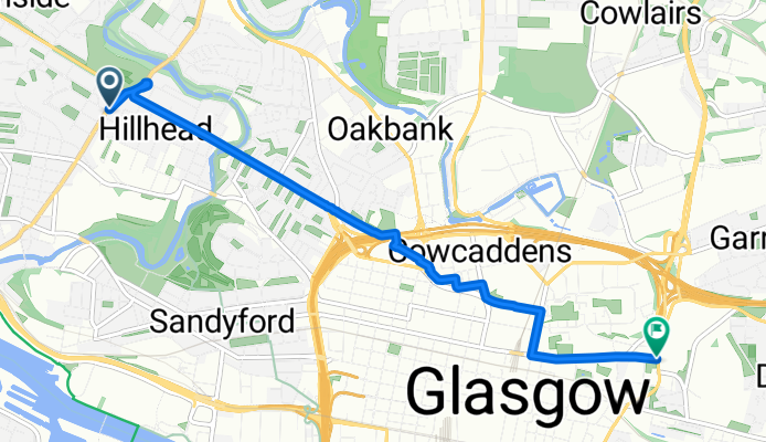
Byres Road to Glasgow Royal Infirmary
A cycling route starting in Glasgow, Scotland, United Kingdom.
Overview
About this route
West End to Byres Road via GWR and Cowcaddens. GWR is much quieter before 8.10am, after that it is quite busy with the school drop offs etc. You need to take care on the main roads and 'take the lane' where necessary. From Cowcaddens you can go via Caledonian Uni, then through Townhead to GRI - this is quietest although the junction from the back of Strathclyde Uni is tricky. Or you can go along Dobbies Loan but there are lots of traffic lights. Cathedral Street is the most direct route but can be busy with buses.
- -:--
- Duration
- 4.6 km
- Distance
- 36 m
- Ascent
- 24 m
- Descent
- ---
- Avg. speed
- ---
- Max. altitude
Route quality
Waytypes & surfaces along the route
Waytypes
Quiet road
2 km
(42 %)
Road
1 km
(22 %)
Surfaces
Paved
3 km
(64 %)
Asphalt
2.8 km
(61 %)
Paved (undefined)
0.1 km
(3 %)
Continue with Bikemap
Use, edit, or download this cycling route
You would like to ride Byres Road to Glasgow Royal Infirmary or customize it for your own trip? Here is what you can do with this Bikemap route:
Free features
- Save this route as favorite or in collections
- Copy & plan your own version of this route
- Sync your route with Garmin or Wahoo
Premium features
Free trial for 3 days, or one-time payment. More about Bikemap Premium.
- Navigate this route on iOS & Android
- Export a GPX / KML file of this route
- Create your custom printout (try it for free)
- Download this route for offline navigation
Discover more Premium features.
Get Bikemap PremiumFrom our community
Other popular routes starting in Glasgow
 Neilston Loop
- Distance
- 35.6 km
- Ascent
- 246 m
- Descent
- 246 m
- Location
- Glasgow, Scotland, United Kingdom
 SCOTLAND (rough guide)
- Distance
- 1,417.7 km
- Ascent
- 2,428 m
- Descent
- 2,418 m
- Location
- Glasgow, Scotland, United Kingdom
 Glasgow South
- Distance
- 111.1 km
- Ascent
- 738 m
- Descent
- 763 m
- Location
- Glasgow, Scotland, United Kingdom
 Cleveland Street 20 to Robertson Lane 55
- Distance
- 1.8 km
- Ascent
- 13 m
- Descent
- 20 m
- Location
- Glasgow, Scotland, United Kingdom
 Glasgow - Ardrossan
- Distance
- 61.2 km
- Ascent
- 354 m
- Descent
- 352 m
- Location
- Glasgow, Scotland, United Kingdom
 Maryhill Road 822 to Peel Street 7
- Distance
- 19.5 km
- Ascent
- 528 m
- Descent
- 632 m
- Location
- Glasgow, Scotland, United Kingdom
 from Glassgow to Callander
- Distance
- 61.8 km
- Ascent
- 868 m
- Descent
- 835 m
- Location
- Glasgow, Scotland, United Kingdom
 100km ride
- Distance
- 104.8 km
- Ascent
- 449 m
- Descent
- 449 m
- Location
- Glasgow, Scotland, United Kingdom
Open it in the app