

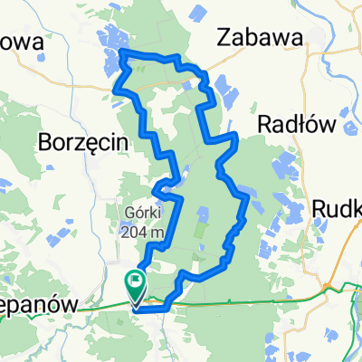
Trasa objazdowa
A cycling route starting in Maszkienice, Lesser Poland Voivodeship, Poland.
Overview
About this route
Okocim, Bocheniec, Dębno, Porąbka Uszewska, Łysa Góra, Jaworsko, Melsztyn, Zakliczyn, Paleśnica, Gródek nad Dunajcem, Rożnów, Tropie, Tropsztyn, Czchów, Brzesko
- -:--
- Duration
- 118.7 km
- Distance
- 920 m
- Ascent
- 920 m
- Descent
- ---
- Avg. speed
- ---
- Max. altitude
Route quality
Waytypes & surfaces along the route
Waytypes
Road
36.8 km
(31 %)
Quiet road
34.4 km
(29 %)
Surfaces
Paved
79.5 km
(67 %)
Asphalt
78.3 km
(66 %)
Paved (undefined)
1.2 km
(1 %)
Undefined
39.2 km
(33 %)
Continue with Bikemap
Use, edit, or download this cycling route
You would like to ride Trasa objazdowa or customize it for your own trip? Here is what you can do with this Bikemap route:
Free features
- Save this route as favorite or in collections
- Copy & plan your own version of this route
- Split it into stages to create a multi-day tour
- Sync your route with Garmin or Wahoo
Premium features
Free trial for 3 days, or one-time payment. More about Bikemap Premium.
- Navigate this route on iOS & Android
- Export a GPX / KML file of this route
- Create your custom printout (try it for free)
- Download this route for offline navigation
Discover more Premium features.
Get Bikemap PremiumFrom our community
Other popular routes starting in Maszkienice
 Trasa objazdowa
- Distance
- 118.7 km
- Ascent
- 920 m
- Descent
- 920 m
- Location
- Maszkienice, Lesser Poland Voivodeship, Poland
 radlow-2
- Distance
- 42.8 km
- Ascent
- 115 m
- Descent
- 119 m
- Location
- Maszkienice, Lesser Poland Voivodeship, Poland
 Treningowa 3, 50km
- Distance
- 47.9 km
- Ascent
- 298 m
- Descent
- 298 m
- Location
- Maszkienice, Lesser Poland Voivodeship, Poland
 Lokalne Górki
- Distance
- 55.2 km
- Ascent
- 784 m
- Descent
- 783 m
- Location
- Maszkienice, Lesser Poland Voivodeship, Poland
 Zamek Dębno
- Distance
- 33.2 km
- Ascent
- 301 m
- Descent
- 284 m
- Location
- Maszkienice, Lesser Poland Voivodeship, Poland
 1 2020 Przechyba 2019
- Distance
- 208.3 km
- Ascent
- 2,235 m
- Descent
- 2,236 m
- Location
- Maszkienice, Lesser Poland Voivodeship, Poland
 bieszczady 2013 v2
- Distance
- 211.2 km
- Ascent
- 1,169 m
- Descent
- 749 m
- Location
- Maszkienice, Lesser Poland Voivodeship, Poland
 tryrtyt
- Distance
- 101.1 km
- Ascent
- 645 m
- Descent
- 642 m
- Location
- Maszkienice, Lesser Poland Voivodeship, Poland
Open it in the app